
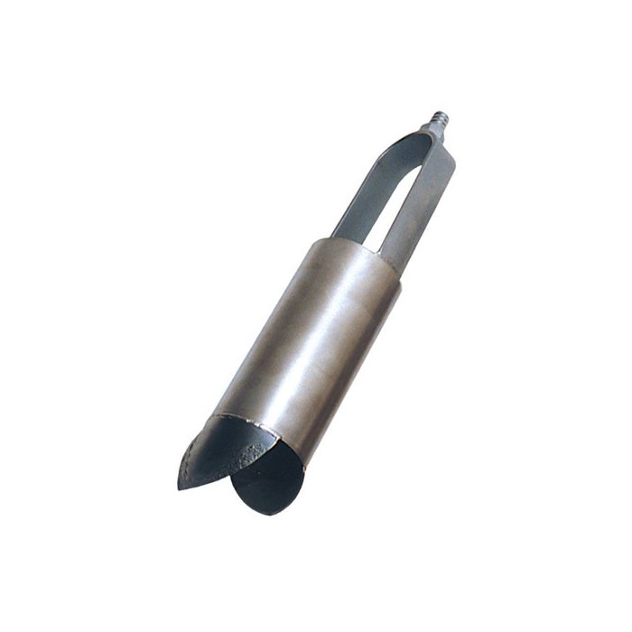
AMS Signature Series Soil Augers
The AMS Signature Series soil augers feature an enhanced version of the already trusted AMS threaded connection, for reliable, uniform samples in various soil sampling applications.
Features
- Signature Series is thicker and more durable than traditional threads
- Connection and disassembly with 2 1/2 turns
- Zinc-coated auger extensions improve rust resistance
Starting At
$213.69
Stock
Drop Ships From
Manufacturer
Fondriest Exclusives
- Expedited repair and warranty service
- Lifetime technical support
- More
Signature Series Connection
The AMS Signature Series connection is an enhanced version of the already trusted AMS threaded connection. The Signature Series features zinc coated extensions to improve rust resistance as well as a larger capacity auger with no weld or grind marks for easy decontamination. The Signature Series thread design is available on a variety of AMS regular, mud, dutch and sand augers, cross handles, extensions, core samplers, slide hammers and adapters.
Regular Soil Augers
AMS Regular Augers are designed for use in most soil types. The AMS regular soil auger is commonly used for obtaining disturbed soil samples at or near the surface and for boring to depths where soil samples may be obtained with a separate soil sampler or soil core sampler. The bits of the regular soil auger are open to allow entry of small soil clumps and relatively small rocks and particles.
Mud Augers
AMS Mud Augers utilize a laser-cut, open cylinder design for easy removal of heavy, wet, or clay soils. The AMS mud auger features two openings in the cylinder wall to facilitate emptying as well as wider spaced bits than the AMS regular soil auger to ease entry of sticky soils.
Sand Augers
AMS Sand Augers are designed for use in sands and dry soils. The AMS sand auger uses a closed bit design with a restricted opening to prevent the loss of sampled material during retrieval. The sand auger has a cylinder similar to the regular soil auger, but the inner edges of the sand auger bits touch at their mid point to make the sand auger a much more reliable auger in loose, unconsolidated soil conditions.
Dutch Augers
The AMS Dutch Auger allows you to easily collect disturbed soil samples in heavily rooted areas. Hand forged from high-carbon steel and honed to a fine cutting edge, this auger will cut through highly fibrous and heavily rooted soils. It is excellent for use in, forests, vineyards and orchards. The unique open design of the dutch auger also allows for easier removal of hard or wet soils.
Questions & Answers
Select Options
Products
0 Item Selected
Image
Part #
Description
Price
Stock
Quantity

350.08
2 1/4" Signature Regular Auger
$213.69
Drop Ships From
Manufacturer

350.07
2 3/4" Signature Regular Auger
$206.22
Drop Ships From
Manufacturer

350.06
3 1/4" Signature Regular Auger
$187.08
Drop Ships From
Manufacturer

350.05
4" Signature Regular Auger
$207.32
Drop Ships From
Manufacturer

350.20
2 1/4" Signature Mud Auger
$240.42
Drop Ships From
Manufacturer

350.19
2 3/4" Signature Mud Auger
$237.23
Drop Ships From
Manufacturer

350.18
3 1/4" Signature Mud Auger
$225.33
Drop Ships From
Manufacturer

350.17
4" Signature Mud Auger
$266.77
Drop Ships From
Manufacturer

350.42
2 1/4" Signature Sand Auger
$232.69
Drop Ships From
Manufacturer

350.41
2 3/4" Signature Sand Auger
$229.75
Drop Ships From
Manufacturer

350.40
3 1/4" Signature Sand Auger
$228.04
Drop Ships From
Manufacturer

350.39
4" Signature Sand Auger
$234.29
Drop Ships From
Manufacturer

350.61
2" Signature Dutch Auger
$259.17
Drop Ships From
Manufacturer

350.59
3" Signature Dutch Auger
$259.17
Drop Ships From
Manufacturer

400.57
2 1/2" Signature Open Faced Auger
$250.47
Drop Ships From
Manufacturer

401.67
2" Signature Edelman Combination Auger
$250.11
Drop Ships From
Manufacturer

401.70
2 3/4" Signature Edelman Combination Auger
$257.09
Drop Ships From
Manufacturer

401.73
4" Signature Edelman Combination Auger
$278.30
Drop Ships From
Manufacturer

401.76
6" Signature Edelman Combination Auger
$329.18
Drop Ships From
Manufacturer

401.85
2 3/4" Signature Edelman Clay Auger
$250.11
Drop Ships From
Manufacturer

401.88
4" Signature Edelman Clay Auger
$269.84
Drop Ships From
Manufacturer

401.79
2 3/4" Signature Edelman Sand Auger
$272.54
Drop Ships From
Manufacturer

401.82
4" Signature Edelman Sand Auger
$299.51
Drop Ships From
Manufacturer

401.92
2 3/4" Signature Edelman Coarse Sand Auger
$347.44
Drop Ships From
Manufacturer

401.95
2 3/4" Signature Edelman Stony Soil Auger
$275.37
Drop Ships From
Manufacturer

401.98
4" Signature Edelman Stony Soil Auger
$306.50
Drop Ships From
Manufacturer
Accessories
0 Item Selected


Notice: At least 1 product is not available to purchase online
Related Products
In The News


