

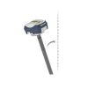
Eos Skadi 200 RTK GNSS Receiver
The Skadi 200 is an entry-level RTK-enabled GNSS receiver with support for dual-frequency on all GNSS constellations to obtain reliable centimeter-level RTK accuracy in the field.
Features
- Works with both SBAS and RTK networks
- Optional Skadi Tilt Compensation captures points quickly without having to level a survey range pole
- Compatible with Skadi Smart Handle for Invisible Range Pole and Extensible Virtual Range Pole features
Your Price
$6,695.00
Stock
1
AVAILABLE
Fondriest Exclusives
- Free ground shipping
- Expedited repair and warranty service
- Lifetime technical support
- More
Overview
The Skadi 200 is the entry-level RTK-enabled GNSS receiver in the Skadi Series from Eos Positioning Systems. With support for dual-frequency on all GNSS constellations, the Skadi 200 lets you obtain reliable centimeter-level RTK accuracy in the field. The Skadi 200 is compatible with any existing RTK network, CORS network, and base station. It is also compatible with free SBAS signals in areas without RTK coverage, and it is device agnostic to work with any iOS, Android, or Windows mobile device.
In addition to the accuracy and performance you would expect from any Eos GNSS receiver, the Skadi 200 also includes several advanced mapping capabilities available only in the Skadi Series product line. These include an integrated antenna and hot-swap, all-day battery pack. Moreover, the Skadi 200 can be activated with the Skadi Tilt Compensation so you can remain more productive at every point by not having to level your physical range pole.
Finally, your included Skadi Standard Handle may be optionally upgraded to the Skadi Smart Handle to take advantage of two exciting features. First, the Invisible Range Pole provides continuous elevation measurements to the ground. Additionally, the Extensible Virtual Range Pole lets you remotely capture assets located a short distance away that are on the ground and in trenches.
Skadi Tilt Compensation
When you activate Skadi Tilt Compensation, you eliminate the need to level your antenna while performing RTK data collection on a range pole. With Skadi Tilt Compensation activated, you introduce only .3 mm (.01 inch) of inaccuracy per degree of tilt.
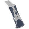
Skadi Smart Handle
The Skadi Smart Handle is a physical upgrade to your included Skadi Standard Handle. The smart handle features two exciting and powerful features. These features include the following:
Invisible Range Pole
The Invisible Range Pole is an innovative approach to bringing the benefits of a traditional survey range pole into your hand without the cumbersome physical weight. With the Invisible Range Pole feature, you carry a virtual gimbal that keeps you plumb to the ground. Raise, lower, or tilt the receiver, your elevation to the ground is continuously computed below the Skadi receiver in your hand, thanks to the exciting combination of LiDAR and MEMS technologies.
Extensible Virtual Range Pole
This exciting and innovative feature allows you to extend the reach of your data collection beyond the position you physically occupy. Using a built-in green laser pointer, now you can “shoot” short-distance assets on the ground while retaining high accuracy. This is particularly useful for assets in trenches and similar environments. The Extensible Virtual Range Pole has an approximate range of about seven meters (23 feet) in bright sunlight conditions (performance may vary based on target reflectivity).
- Skadi 200 GNSS Receiver with Integrated Antenna
- Pole Mounting Plate for Skadi Series
- Skadi Standard Handle (upgradable to Skadi Smart Handle)
- Phone Mounting Bracket for Skadi Series Handles
- Tablet Mounting Bracket for Skadi Series Handles
- Skadi Series Li-Ion Battery Pack
- USB-C Power Block
- USB-C Cable
- Skadi Series Hardshell Case
Questions & Answers
Select Options
Products
0 Item Selected
Image
Part #
Description
Price
Stock
Quantity

SKADI200RTK-KIT
Skadi 200 dual-frequency RTK GNSS receiver
$6,695.00
1 Available
Accessories
0 Item Selected


Notice: At least 1 product is not available to purchase online
Related Products


In The News


