
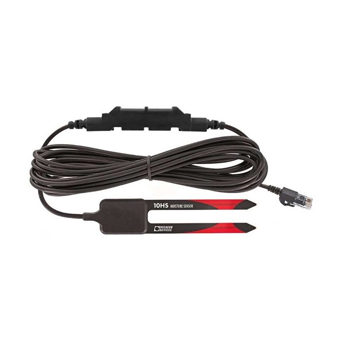
HOBO ECH2O 10HS Soil Moisture Smart Sensor
The HOBO ECH2O 10HS soil moisture smart sensor measures a large 1-liter volume of soil, providing a more accurate picture of average soil moisture.
Features
- Provides data directly in volumetric water content
- High-frequency (70 MHz) circuit provides good accuracy even in high-salinity and sandy soils
- Compatible with Onset stand-alone and web-based weather stations
Your Price
$209.00
Stock
Check
Availability
Fondriest Exclusives
- Free ground shipping
- Expedited repair and warranty service
- Lifetime technical support
- More
Overview
The HOBO ECH2O 10HS soil moisture smart sensor measures a large 1-liter volume of soil, providing a more accurate picture of average soil moisture. The sensor integrates the field-proven 10HS Sensor and a 12-bit A/D, providing ±3% accuracy in most soil conditions and ±2% accuracy with soil-specific calibration.
Mechanics
The 10cm probes measure soil moisture over a larger volume of soil, helping to average out any soil variability. Readings are provided directly in volumetric water content. The sensor's high-frequency design minimizes salinity and textural effects and gives it a wide measurement range.
Measurement range in soil: 0 to 0.570 m³/m³ (volumetric water content)
Accuracy:
±0.033 m³/m³ (±3.3%) typical 0 to +50°C (+32° to +122°F) for mineral soils up to 10 dS/m
±0.020 m³/m³ (±2%) with soil specific calibration
Resolution: 0.0008 m³/m³ (0.08%)
Soil probe dimensions: 160 x 32 x 2 mm (6.5 x 1.25 x 0.08 in.)
Weight: 190 grams (6.7 oz)
Decagon probe part no.: 10HS
Sensor operating temperature:
0° to +50°C (+32° to +122°F). Although the sensor probe and cable can safely operate at below-freezing temperatures (to -40°C/F) and the smart sensor tube (the white portion of the sensor cable that houses the electronics) can be exposed to temperatures up to +70°C (+158°F), the soil moisture data collected at these extreme temperatures is outside of the sensor's accurate measurement range. Extended temperatures above +50°C (+122°F) will decrease logger battery life when using for the S-SMD-M005 smart sensor.
Volume of influence: 1 liter (33.8 oz)
Sensor frequency: 70 MHz
Bits per sample: 12
Number of data channels: 1
Measurement averaging option: No
Cable length available: 5 m (16 ft)
Length of Smart Sensor network cable: 0.5 m (1.6 ft)
Questions & Answers
Select Options
Products
0 Item Selected
Image
Part #
Description
Price
Stock
Quantity

S-SMD-M005
ECH2O 10HS soil moisture smart sensor for large areas, 5m cable
$209.00
Check Availability
Accessories
0 Item Selected


Notice: At least 1 product is not available to purchase online
Related Products
In The News


