
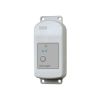
HOBO MX Soil Moisture Loggers
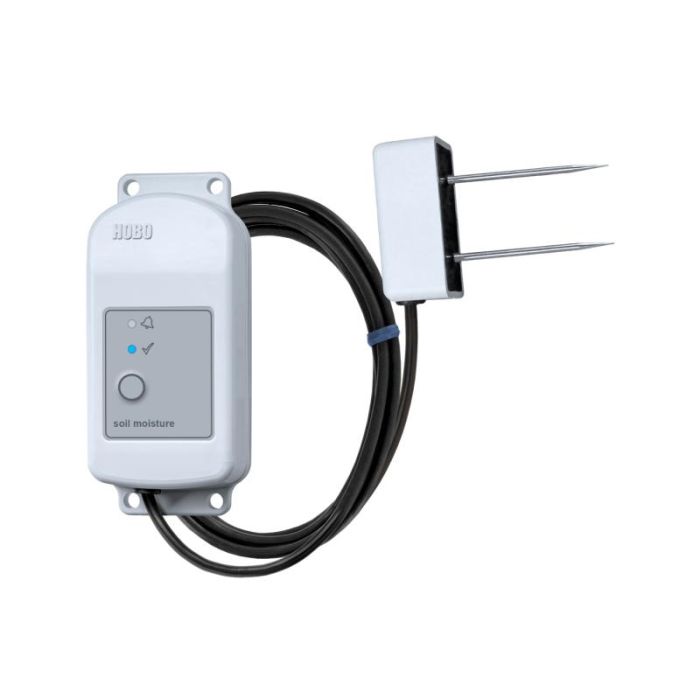
The HOBO MX Soil Moisture Data Loggers are the industry’s only low-cost, fully integrated soil moisture loggers with Bluetooth wireless data offload.
Features
- Ready to deploy, with pre-attached sensors
- Easy configuration and data offload with the free HOBOconnect app
- Durable TEROS 10 soil moisture sensor lasts over 10 years in the field
Starting At
$375.00
Stock
Check
Availability
Fondriest Exclusives
- Free ground shipping
- Expedited repair and warranty service
- Lifetime technical support
- More
Overview
The HOBO MX Soil Moisture Data Loggers are the industry’s only low-cost, fully integrated soil moisture loggers with Bluetooth wireless data offload. Available in two models--one that measures soil moisture (HOBO MX2306) and one that measures both soil moisture and temperature (HOBO MX2307)--these loggers are ideal for users looking for the accurate data they need to save water, improve crop yields, reduce harmful runoff, and protect ecosystems.
Mechanics
With just a mobile phone, tablet, or Windows laptop running the free HOBOconnect app, users can set up and download data wirelessly via Bluetooth when within 100 feet of the logger, making it easy to retrieve data from hard-to-access field locations. For indoor areas, such as greenhouses, users can add the MX Gateway for remote access to data in the cloud-based HOBOlink software.
| Soil Moisture: Volumetric Water Content (VWC) | |
| Measurement Range |
0.00 to 0.64 m³/m³ in mineral soils 0.00 to 0.70 m³/m³ in soilless media |
| Accuracy |
±0.031 m³/m³ typical in mineral soils that have solution EC <8 dS/m ±0.051 m³/m³ typical in soilless media |
| Resolution |
0.001 m³/m³ |
| Dielectric Measurement Frequency |
70 MHz |
| Temperature Sensor (MX2307) | |
| Range |
-40 to 100°C (-40 to 212°F), with tip and cable immersion in fresh water up to 50°C (122°F) for one year |
| Accuracy |
±0.25°C from -40 to 0°C (±0.45 from -40 to 32°F)
±0.2°C from 0 to 70°C (±0.36 from 32 to 158°F)
±0.25°C from 70 to 100°C (±0.45 from 158 to 212°F)
|
| Resolution |
0.04°C (0.072°F)
|
| Drift |
<0.01°C per year (0.018°F per year)
|
| Response Time |
3 minutes in air moving 1 m/s; 20 seconds in stirred water 4 minutes in air moving 1 m/s with RS3-B Solar Radiation Shield |
| Logger | |
| Operating Range |
-25° to 60°C (-13° to 140°F)
|
| Radio Power |
1 mW (0 dBm)
|
| Transmission Range |
Approximately 30.5 m (100 ft) line-of-sight |
| Wireless Data Standard |
Bluetooth Low Energy (Bluetooth Smart) |
| Logging Rate |
1 second to 18 hours |
| Logging Modes |
Fixed interval (normal, statistics) or burst |
| Memory Modes |
Wrap when full or stop when full |
| Start Modes |
Immediate, push button, date & time, or next interval |
| Stop Modes |
When memory full, push button, date & time, or after a set logging period |
| Time Accuracy |
±1 minute per month 0° to 50°C (32° to 122°F) |
| Battery Type |
2/3 AA 3.6 Volt lithium, user replaceable |
| Battery Life |
2 years, typical with logging interval of 1 minute and Bluetooth Always On enabled; 5 years, typical with logging interval of 1 minute and Bluetooth Always On disabled. Faster logging intervals and statistics sampling intervals, burst logging, remaining connected with the app, excessive downloads, and paging may impact battery life. |
| Memory |
110,000 measurements, maximum (472 kB) |
| Full Memory Download Time |
Approximately 60 seconds; may take longer the further the device is from the logger |
| Dimensions |
Logger housing: 10.8 x 5.08 x 2.24 cm (4.25 x 2.0 x 0.88 in.)
Soil moisture sensor: 7.5 x 5.1 x 2.4 cm (2.95 x 2.02 x 0.95 inches)
Soil moisture sensor needle length: 5.4 cm (2.13 inches) Soil moisture sensor needle diameter: 0.32 cm (0.13 inches) Temperature sensor (MX2307) diameter: 0.53 cm (0.21 in.) Sensor cable length: 2 m (6.56 ft) |
| Weight |
MX2306: 229 g (80 oz) MX2307: 267 g (94 oz) |
| Materials |
Logger: Acetal, silicone gasket, stainless steel screws Soil Moisture Sensor: ASA plastic body with polyurethane epoxy filling and stainless steel pins Temperature Sensor (MX2307): Stainless steel waterproof tip Cable: PVC, UV resistant and rodent repellent (soil moisture sensor cable) |
| Environmental Rating |
Temperature sensor and cable (MX2307): Immersion in water up to 50°C (122°F) for 1 year |
- HOBO MX2306 or HOBO MX2307 Data Logger with 2m cable(s) and attached sensor(s)
- HOBO MX Soil Moisture Logger Quick Start
- Screws
- Cable ties
Questions & Answers
Select Options
Products
0 Item Selected
Image
Part #
Description
Price
Stock
Quantity

MX2306
HOBO MX soil moisture logger, 2m cable
$375.00
Check Availability

MX2307
HOBO MX soil moisture & temperature logger, 2m cable
$435.00
Check Availability
Accessories
0 Item Selected


Notice: At least 1 product is not available to purchase online
Related Products
In The News


