
LI-COR LI-191R Line PAR Sensors
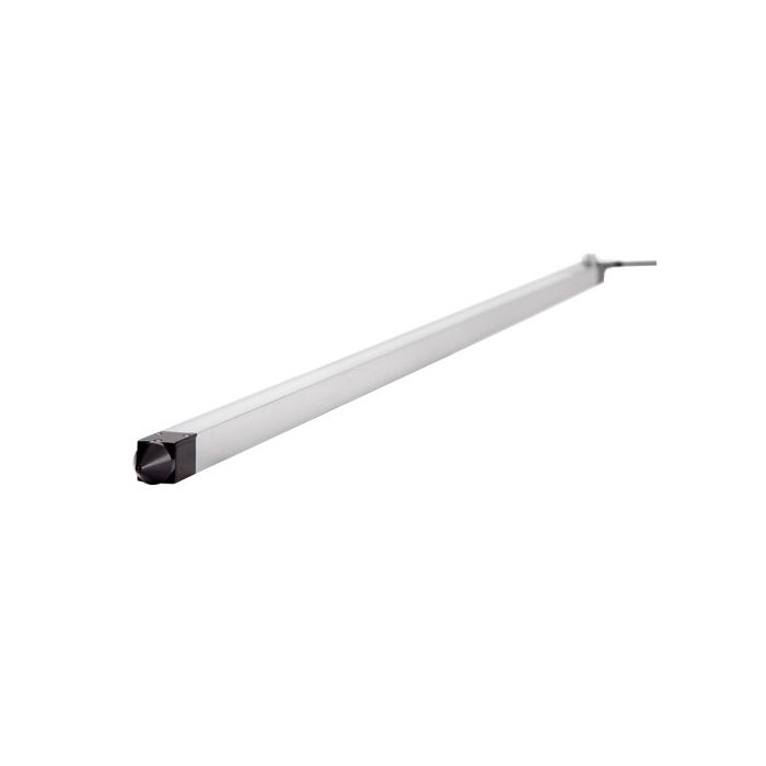
The LI-COR LI-191R Line PAR Sensor measures photosynthetically active radiation (PAR) over its one-meter length for use within a plant canopy.
Features
- Spatially averages PPFD over its 1m length
- Uses a 1m quartz rod under a diffuser to conduct light to a single Quantum sensor
- Improved water resistance for long-term outdoor deployment
Starting At
$3,640.00
Stock
Check
Availability
Fondriest Exclusives
- Free ground shipping
- Expedited repair and warranty service
- Lifetime technical support
- More
Overview
The LI-191R Line Quantum Sensor measures Photosynthetically Active Radiation (PAR) integrated over its 1-meter length. It is used to measure sunlight under a plant canopy, where the light field is non-uniform. It measures light in units of Photosynthetic Photon Flux Density (PPFD), which is expressed as μmol s-1 m-2.
Mechanics
The entire LI‑191R diffuser is sensitive to light over its 1-meter length. Since the diffuser is one continuous piece, the LI‑191R essentially integrates an infinite number of points over its surface into a single value that represents light from the entire 1-meter length. The diffuser and single photodiode in the LI‑191R provide stable, integrated measurements that are superior to averages provided by many linear sensors. Optical filters block radiation with wavelengths beyond 700 nm, which is critical for under-canopy measurements, where the ratio of infrared to visible light may be high.
- Absolute Calibration: ± 10% traceable to National Institute of Science and Technology (NIST). The LI-191 is calibrated via transfer calibration
- Sensitivity: Typically 7 μA per 1,000 μmol s-1 m-2
- Linearity: Maximum deviation of 1% up to 10,000 μmol s-1 m-2
- Response Time: 10 μs
- Temperature Dependence: ± 0.15% per °C maximum
- Cosine Correction: Acrylic diffuser
- Azimuth: < ± 2% error over 360° at 45° elevation
- Sensitivity Variation over Length: ± 7% maximum using a 2.54 cm (1”) wide beam from an incandescent light source.
- Sensing Area: 1 m × 12.7 mm (39.4” × 0.50”)
- Detector: High stability silicon photovoltaic detector (blue enhanced)
- Sensor Housing: Weatherproof anodized aluminum housing with acrylic diffuser and stainless steel hardware.
- Size: 121.3 L × 2.54 W × 2.54 cm D (47.7” × 1.0” × 1.0”)
- Weight: 1.4 kg (3.0 lbs.)
- Cable Length: 2 m, 5 m (6.5', 16.4')
- (1) LI-191R Line PAR Sensor
- (1) Bubble level
- (1) Detachable 10 ft. cable
- (1) Hard-sided carrying case
Questions & Answers
Select Options
Products
0 Item Selected
Image
Part #
Description
Price
Stock
Quantity

LI-191R-BNC-2
Line Quantum sensor with microamp output, 2m cable with BNC connector
$3,640.00
Check Availability

LI-191R-BNC-5
Line Quantum sensor with microamp output, 5m cable with BNC connector
$3,690.00
Check Availability

LI-191R-SMV-2
Line Quantum sensor with standardized mV output, 2m cable with bare leads
$3,710.00
Check Availability

LI-191R-SMV-5
Line Quantum sensor with standardized mV output, 5m cable with bare leads
$3,750.00
Check Availability
Accessories
0 Item Selected


Notice: At least 1 product is not available to purchase online
Related Products
In The News


