
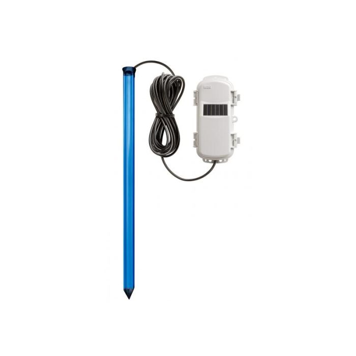
HOBOnet Wireless Multi-Depth Soil Moisture Sensor
The Onset HOBOnet Multi-Depth Soil Moisture Sensor is a wireless sensor that works with the HOBOnet system to measure soil moisture and soil temperature at multiple depths with a single probe.
Features
- 900 MHz wireless mesh self-healing technology
- 450 to 600 meter (1,500 to 2,000 feet) wireless range and up to five hops
- Up to 50 wireless sensors or 336 data channels per HOBO RX station
Starting At
$839.00
Stock
Check
Availability
Fondriest Exclusives
- Free ground shipping
- Expedited repair and warranty service
- Lifetime technical support
- More
Overview
The Onset HOBOnet Multi-Depth Soil Moisture Sensor is a wireless sensor that works with the HOBOnet system to measure soil moisture and soil temperature at multiple depths with a single probe. This durable sensor is available in three probe lengths, for measurements up to 90 cm (35 in) deep.
Mechanics
Featuring GroPoint's TDT5 technology with patented antenna design, this sensor measures soil moisture along the entire length of each probe segment, resulting in the largest volume of influence per measurement section. A high frequency of pulses per measurement provides precise and consistent soil moisture data.
Applications
The optional pilot rod and slide hammer are recommended for quick and easy installation: the PILOT-ROD4 (28") for use with the 3-segment and 4-segment sensors (RXW-GP3A and RXW-GP4A) and the PILOT-ROD6 (40) for use with the 6-segment sensor (RXW-GP6A).
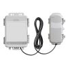
The HOBOnet system is a cost-effective and scalable wireless sensor network for web-enabled monitoring of field conditions for applications such as crop management, research, and greenhouse operations. Because it's wireless, users can deploy a network of sensors to easily monitor multiple points with a single system, while avoiding the risk of long cables that can interfere with field operations. Sensors are easily linked to the network, and data can be accessed through HOBOlink, Onset's innovative cloud software platform.
| Soil Moisture: Volumetric Water Content (VWC) | ||||||||||||||||||||||||||
| Measurement Range | In soil: 0 to 0.550 m³/m³ (volumetric water content) | |||||||||||||||||||||||||
| Accuracy | ±0.02 m³/m³ (±2%) in most soils typical from 0° to 50°C (32° to 122°F)* | |||||||||||||||||||||||||
| Resolution | 0.001 m³/m³ | |||||||||||||||||||||||||
| Temperature | ||||||||||||||||||||||||||
| Measurement Range | -20° to 70°C (-4° to 158°F) | |||||||||||||||||||||||||
| Accuracy | ±0.5°C (0.9°F) | |||||||||||||||||||||||||
| Resolution | 0.1°C (0.18°F) | |||||||||||||||||||||||||
| Depths Measured (see below) | ||||||||||||||||||||||||||
| RXW-GP3A-xxx | 45 cm (18 inches) total; three soil moisture zones, six temperature depths | |||||||||||||||||||||||||
| RXW-GP4A-xxx | 60 cm (24 inches) total; four soil moisture zones, six temperature depths | |||||||||||||||||||||||||
| RXW-GP6A-xxx | 90 cm (35 inches) total; six soil moisture zones, nine temperature depths | |||||||||||||||||||||||||
| Wireless Mote | ||||||||||||||||||||||||||
| Operating Temperature Range | Sensor: -20° to 70°C (-4° to 158°F) Mote: -25° to 60°C (-13° to 140°F) with rechargeable batteries -40° to 70°C (-40° to 158°F) with lithium batteries |
|||||||||||||||||||||||||
| Radio Power | 12.6 mW (+11 dBm) non-adjustable | |||||||||||||||||||||||||
| Transmission Range | Reliable connection to 457.2 m (1,500 ft) line of sight at 1.8 m (6 ft) high Reliable connection to 609.6 m (2,000 ft) line of sight at 3 m (10 ft) high |
|||||||||||||||||||||||||
| Wireless Data Standard | IEEE 802.15.4 | |||||||||||||||||||||||||
| Radio Operating Frequencies | RXW-GPxA-900: 904–924 MHz RXW-GPxA-868: 866.5 MHz RXW-GPxA-921: 921 MHz RXW-GPxA-922: 916–924 MHz |
|||||||||||||||||||||||||
| Modulation Employed | OQPSK (Offset Quadrature Phase Shift Keying) | |||||||||||||||||||||||||
| Data Rate | Up to 250 kbps, non-adjustable | |||||||||||||||||||||||||
| Duty Cycle | <1% | |||||||||||||||||||||||||
| Maximum Number of Motes | Up to 50 wireless sensors or 336 data channels per one HOBO RX station | |||||||||||||||||||||||||
| Logging Rate | Maximum logging interval: 18 hours Recommended minimum logging interval: 5 minutes year round when using solar power with rechargeable batteries, 10 minutes when using non-rechargeable lithium batteries |
|||||||||||||||||||||||||
| Number of Data Channels | RXW-GP3A-xxx: 10 RXW-GP4A-xxx: 11 RXW-GP6A-xxx: 16 |
|||||||||||||||||||||||||
| Battery Type/ Power Source |
Two AA 1.2V rechargeable NiMH batteries, powered by built-in solar panel or two AA 1.5 V non-rechargeable lithium batteries for operating conditions of -40 to 70°C (-40 to 158°F) | |||||||||||||||||||||||||
| Battery Life | With NiMH batteries: Typical 3–5 years when operated in the temperature range -20° to 40°C (-4°F to 104°F) and positioned toward the sun (see Mounting and Positioning the Mote), operation outside this range will reduce the battery service life With non-rechargeable lithium batteries: 1 year with a 10-minute logging interval |
|||||||||||||||||||||||||
| Memory | 16 MB | |||||||||||||||||||||||||
| Dimensions | RXW-GP3A-xxx sensor length: 53.2 cm (20.9 inches) RXW-GP4A-xxx sensor length: 68.2 cm (26.9 inches) RXW-GP6A-xxx sensor length: 98.2 cm (38.7 inches) Sensor diameter: 3 cm (1.2 inches) Cable length: 3.5 m (11 ft 6 in) Mote: 16.2 x 8.59 x 4.14 cm (6.38 x 3.38 x 1.63 inches) |
|||||||||||||||||||||||||
| Weight | RXW-GP3A-xxx sensor: 351 g (12.4 oz) RXW-GP4A-xxx sensor: 408 g (14.4 oz) RXW-GP6A-xxx sensor: 526 g (18.6 oz) Cable: 180 g (6.5 oz) Mote: 226 g (7.97 oz) |
|||||||||||||||||||||||||
| Materials | Sensor: Polycarbonate housing encasing epoxy sealed circuit board Cable: Polyurethane Mote: PCPBT, silicone rubber seal |
|||||||||||||||||||||||||
| Environmental Rating | Mote: IP67, NEMA 6 | |||||||||||||||||||||||||
- HOBOnet Multi-Depth Soil Moisture Sensor
- Two AA 1.2V rechargeable NiMH batteries
- Cable ties
- Screws
Questions & Answers
Select Options
Products
0 Item Selected
Image
Part #
Description
Price
Stock
Quantity

RXW-GP3A-900
HOBOnet wireless multi-depth soil moisture & temperature sensor, 45cm, 3m cable, solar, 900 MHz (US)
$839.00
Check Availability

RXW-GP4A-900
HOBOnet wireless multi-depth soil moisture & temperature sensor, 60cm, 3m cable, solar, 900 MHz (US)
$959.00
Check Availability

RXW-GP6A-900
HOBOnet wireless multi-depth soil moisture & temperature sensor, 90cm, 3m cable, solar, 900 MHz (US)
$1,115.00
Check Availability
Accessories
0 Item Selected


Notice: At least 1 product is not available to purchase online
Related Products
In The News


