
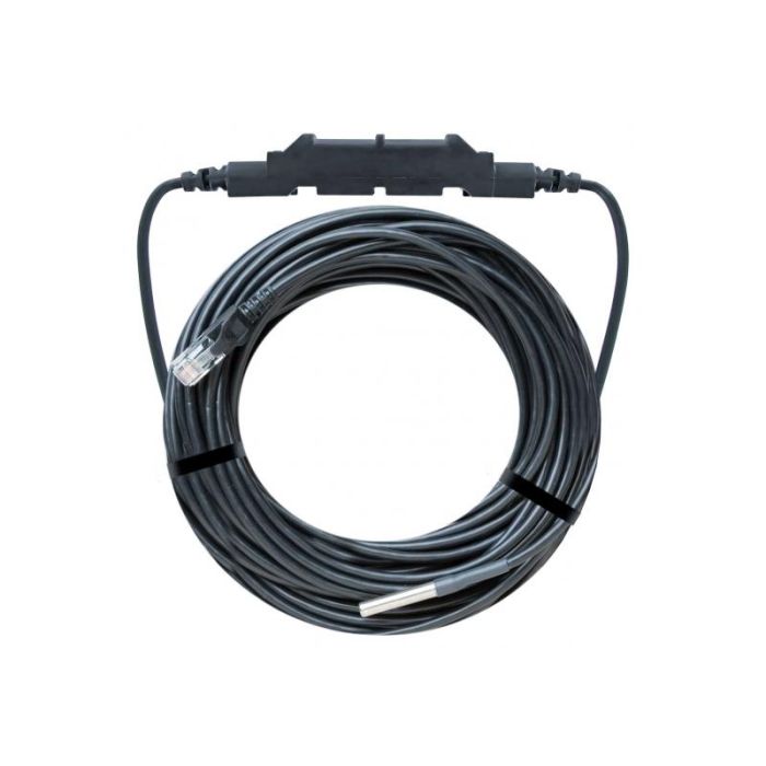
HOBO Temperature Smart Sensor
The Onset Temperature Smart Sensor provides < ± 0.2° C total accuracy (< ±0.36° F) and resolution of < ± 0.03° C (< ±0.054° F) over the range of 0° to 50° C (32° to 122° F).
Features
- Measurement range of -40° to 100°C (-40° to 212°F)
- Stainless steel sensor tip
- Sensor and cable rated for immersion in water or soil up to 50°C for up to 1 year
Starting At
$119.00
Stock
Check
Availability
Fondriest Exclusives
- Expedited repair and warranty service
- Lifetime technical support
- More
Overview
The Onet 12-bit Temperature Smart Sensor provides < ± 0.2° C total accuracy (< ±0.36° F) and resolution of < ± 0.03° C (< ±0.054° F) over the range of 0° to 50° C (32° to 122° F). The full measurement range is -40° to 100° C (-40° to 212° F). A selectable measurement-averaging feature further improves accuracy. Available in cable lengths of 2m, 6m and 17m.
|
Measurement Range |
-40° to 100°C (-40° to 212°F) – sensor tip |
| Accuracy | < ±0.2°C from 0° to 50°C (< ±0.36°F from 32° to 122°F)* |
| Resolution | <0.03°C from 0° to 50°C (<0.054°F from 32° to 122°F) |
| Drift | <0.1°C (0.18°F) per year** |
| Response Time (to 90% of change) | <2 minutes typical in 2 m/sec (4.5 mph) moving air flow <1 minute typical in stirred water bath |
| Environmental Operating Ranges | Smart sensor adapter: -40° to 75°C (-40°F to 167°F); weatherproof, IP67 Stainless-steel sensor tip and cable jacket: Waterproof over the range of -40° to 50°C (-40°F to 122°F) for 1 year; operation up to 100°C (212°F) in air |
| Housings | Stainless steel waterproof sensor tip; weatherproof polyamide housing for smart sensor adapter |
| Dimensions | Temperature probe: 5.0 x 26 mm (0.2 x 1.0 inches) |
| Weight | 2 meter: 0.09 g (3.3 oz) 6 meter: 0.14 g (5.2 oz) 17 meter: 0.30 g (11.2 oz) |
| Bits per Sample | 12 |
| Number of Data Channels*** | 1 |
| Measurement Averaging Option | Yes |
| Cable Lengths Available | 2 m (6.6 ft) S-TMB-M002 6 m (19.7 ft) S-TMB-M006 17 m (55.8 ft) S-TMB-M017 |
| Length of Smart Sensor Network Cable | 0.5 m (1.6 ft) for all models |
*Radiation Shield strongly recommended for use in sunlight (listed in Accessories tab)
**The drift specification of <0.1°C (0.18°F) per year may be exceeded when using the probe continuously in water >50°C (122°F).
***A single HOBO station can accommodate 15 data channels and up to 100 m (328 ft) of smart sensor cable (the digital communications portion of the sensor cables).
Questions & Answers
Select Options
Products
0 Item Selected
Image
Part #
Description
Price
Stock
Quantity

S-TMB-M002
Temperature smart sensor, 2m cable
$119.00
Check Availability

S-TMB-M006
Temperature smart sensor, 6m cable
$135.00
Check Availability

S-TMB-M017
Temperature smart sensor, 17m cable
$159.00
Check Availability
Accessories
0 Item Selected


Notice: At least 1 product is not available to purchase online
Related Products
In The News


