
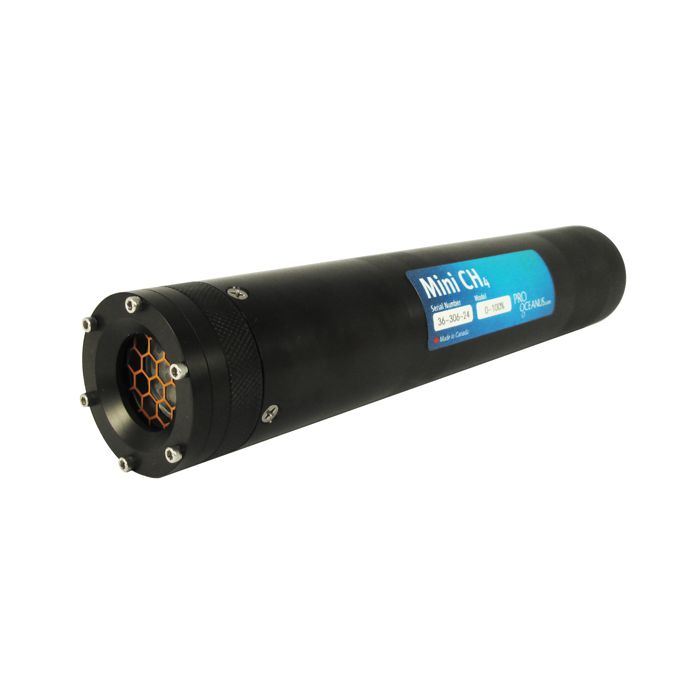
Pro-Oceanus Mini Dissolved CH4 Probe
The Pro-Oceanus Mini CH4 probe is a rugged dissolved methane sensor designed for ocean pipeline leak detection, groundwater, and industrial use.
Features
- Compact size with low power consumption
- Large selection of concentration ranges
- Internal data logger with 2GB flash memory
Your Price
Call
Stock
Check
Availability
Fondriest Exclusives
- Expedited repair and warranty service
- Lifetime technical support
- More
Overview
The Pro-Oceanus Mini CH4 instrument uses infrared detection to measure the partial pressure of CH4 gas dissolved in liquids. Conversion to dissolved methane concentration is simple with known temperature and salinity values.
Mechanics
Mini CH4 submersible instruments are compact, lightweight, plug-and-play sensors designed to measure pCH4 for a range of applications. The instrument also measures total dissolved gas pressure (TDGP), a useful parameter for many applications and data correction.
Applications
With resistance to most corrosive liquids, the Mini CH4 can provide reliable dissolved methane data for many applications. Flow-through and inline adapters are also available for simple industrial solutions.
| Sensor Performance | |
|---|---|
| pCH4 Measurement Ranges | 0-1% CH4 ; by volume (~0-300 μg/L; by mass) 0-10%v/v (~0-3 mg/L) 0-100%v/v (~0-30 mg/L) |
| Total Dissolved Gas Pressure | 0-2 bar |
| Accuracy: pCH4 | ± 3% of max range |
| TDGP | ± 1% |
| Equilibration rate (t63) | ~8 minutes (with water-pumped head) |
| Resolution | 0.1% of max range |
| Physical | |
|---|---|
| Length | 28 cm (11 in) |
| Diameter | 5.3 cm (2.1 in) |
| Weight | Air 0.53 kg (1.2 lbs) Water: -0.06 kg (-0.1 lbs) |
| Housing Material | Acetal Plastic |
| Depth Rating | 0 - 600 m |
| Water Temperature | 0º to 40º C |
| Electrical | |
|---|---|
| Input voltage | 7-24 VDC |
| Power consumption | 85 mW (7 mA @ 12 V) |
| Data output | Digital: RS-232, ASCII format |
| Sample rate | 2 seconds (variable rate with logger/controller) |
All models include:
- Mini CO2 Instrument
- USB memory stick with Oceanus Software and User’s Manual
- QuickStart Guide
Power and communications deck box includes:
- Water-Resistant deck box with Underwater Cable and Connector Sleeve
- 2-meter RS-232 cable
- RS-232-to-USB Converter
- AC to DC 12 V Power Supply
Internal rechargeable battery models include the items above as well as a battery pack and charger.
Questions & Answers
Select Options
Products
0 Item Selected
Image
Part #
Description
Price
Stock
Quantity

M320
Mini dissolved methane (CH4) probe with RS-232 output, includes power/communications box
Request Quote
Check Availability

M330
Mini dissolved methane (CH4) probe with RS-232 output & internal 5 A-Hr 6 VDC rechargeable battery pack, includes power/communications box
Request Quote
Check Availability

M335
Mini dissolved methane (CH4) probe with RS-232 output & internal 5 A-Hr 12 VDC rechargeable battery pack, includes power/communications box
Request Quote
Check Availability

M340
Mini dissolved methane (CH4) probe with RS-232 output & internal 19 A-Hr 6 VDC alkaline battery pack, includes power/communications box
Request Quote
Check Availability
Accessories
0 Item Selected


Notice: At least 1 product is not available to purchase online
Related Products
In The News


