
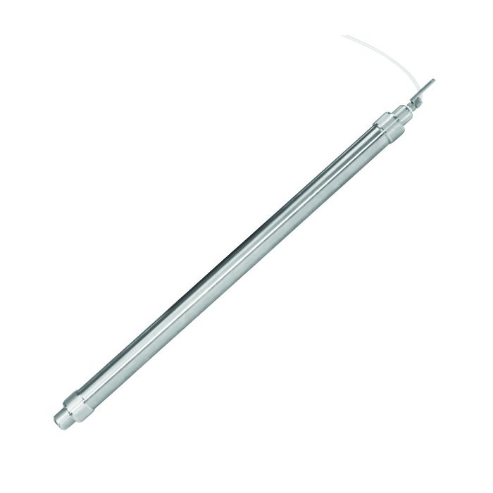
Solinst Model 425 Discrete Interval Sampler
The Solinst Model 425 Discrete Interval Sampler is a stainless steel groundwater sampler designed for use with LDPE tubing mounted on a reel.
Features
- Avoids purging and disposal of purged water
- Obtain high quality discrete zone samples
- Profile wells or open bodies of water
Starting At
$204.00
Stock
Check
Availability
Fondriest Exclusives
- Free ground shipping
- Expedited repair and warranty service
- Lifetime technical support
- More
Overview
The Solinst Model 425 Discrete Interval Sampler is a stainless steel groundwater sampler designed for use with LDPE tubing mounted on a reel. The reel has a pressure attachment for a high-pressure hand pump and a pressure/vent switch, which is used to apply and release the pressure on the sampler. A sample release device is included with each standard Discrete Interval Sampler.
Applications
Discrete interval sampling is ideal for obtaining truly representative groundwater samples from below floating product layers, or for obtaining samples of the product itself. The discrete interval sampler can also be used to profile open bodies of water and boreholes, and to collect samples from distinct levels or points of inflow. The Discrete Interval Sampler is a passive sampler that is pressurized when lowered and upon retrieval to prevent water from mixing at different levels. Designed to give zero purge samples.
Models
Solinst also offers the Model 425-D Deep Sampling Discrete Interval Sampler for obtaining samples from submerged depths as much as 1200m (4000 ft). Biodegradable disposable PVC bailers and stainless steel Point Source Bailers are also available.
- (1) Model 425 Discrete Interval Sampler
- (1) Sample Release Device
Questions & Answers
Select Options
Products
0 Item Selected
Image
Part #
Description
Price
Stock
Quantity

114966
Model 425 Discrete Interval Sampler, 1" x 2 ft.
$204.00
Check Availability

114967
Model 425 Discrete Interval Sampler, 1" x 4 ft.
$370.00
Check Availability

114968
Model 425 Discrete Interval Sampler, 1.66" x 2 ft.
$357.00
Check Availability

115011
Model 425 Discrete Interval Sampler, 1.66" x 4 ft.
$495.00
Check Availability

115012
Model 425 Discrete Interval Sampler, 2" x 2 ft.
$607.00
Check Availability

115013
Model 425 Discrete Interval Sampler, 2" x 4 ft.
$805.00
Check Availability

115342
Model 425-D Deep Sampling Discrete Interval Sampler, 1.66" x 2 ft.
$827.00
Check Availability
Accessories
0 Item Selected


Notice: At least 1 product is not available to purchase online
Related Products
In The News


