
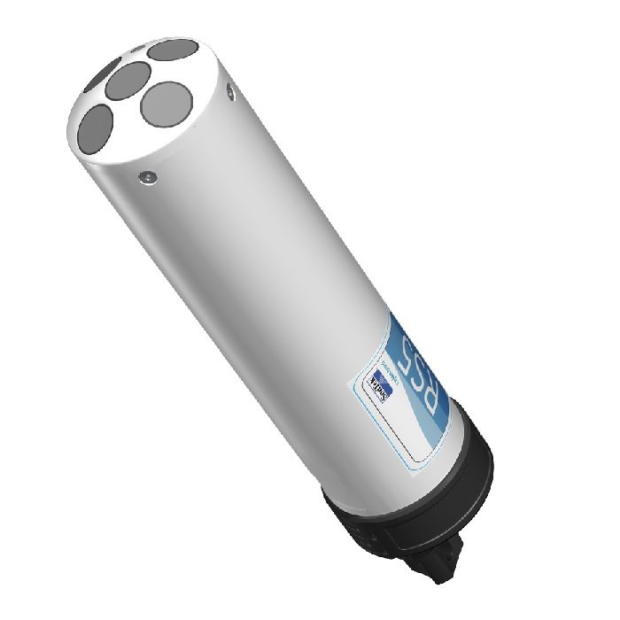
SonTek RS5 Acoustic Doppler Current Profiler
The Sontek HydroSurveyor is a system designed to collect bathymetric, water column velocity profile, and acoustic bottom tracking data as part of a hydrographic survey.
Features
- SmartPulse+ utilizes Pulse-coherent and Broadband acoustic profiling that automatically adjusts based on conditions
- Vertical acoustic beam for the most accurate channel cross-sectional area in discharge applications
- Batteries and Bluetooth radio are housed in the RS5, eliminating external electric boxes
Your Price
Call
Stock
Check
Availability
Fondriest Exclusives
- Expedited repair and warranty service
- Lifetime technical support
- More
Overview
The HydroSurveyor is a system designed to collect bathymetric, water column velocity profile, and acoustic bottom tracking data as part of a hydrographic survey. The two key components of the system are the HydroSurveyor Acoustic Doppler Profiler (ADP) platform, and the powerful, yet user-friendly, data collection software. With the HydroSurveyor platform, SonTek is able to offer an exclusive 5-beam depth sounding device, with built-in navigation, full water column velocity (currents) profiling, full compensation for speed of sound (with the CastAway-CTD), and integrated positioning solution.
| Water Velocity Profiling | Profiling Range | 0.1-6 m (*1) |
| Velocity Range | ±5 m/s | |
| Accuracy | 1% ±0.002 m/s | |
| Resolution | 0.001 m/s | |
| Number of Cells | Up to 128 | |
| Cell Size | 2.5-30 cm | |
| Data Output Rate | 1.0 Hz | |
| Bottom Tracking | Depth Range | 0.1-6 m (*1) |
| Accuracy (*2) | 1% ± 0.002 m/s | |
| Resolution | 0.001 m/s | |
| Depth Measurement | Range | 0.1-6.5 m (*1) |
| Accuracy | 1% ±0.005 m | |
| Sensors | Temperature Sensors | Resolution: ±0.01°C Accuracy: ±0.5°C |
| Compass/Tilt Sensor | Range: ±180° Pitch/Roll, 0-360° Heading Heading Accuracy: ±2° Pitch/Roll Accuracy: ±1° |
|
| Transducers | Total Number | Five, 3.0 Mhz |
| Beam Angle | 25° | |
| Beam Width | 3° | |
| Bandwidth | 25% | |
| Battery Characteristics | Input Voltage | 3.3-4.2 VDC |
| Power Source - Li-Ion | 1x size 18650, Tenergy, Type 30016-04, 3.7Vdc, 2600mAh | |
| Battery Life - 1 x size 18650 | Seven hours continuous use, typical settings (*3) | |
| Power Consumption | 1.0 W (Average) | |
| Dimensions | 19.2 mm x 69.7 mm | |
| Communications | Radio Protocol | Bluetooth Low Energy (BLE5) |
| Range | 100 m (*4) | |
| Bluetooth Compliance | FCC Part 15, FCC ID: XPYNINAB30 ISED Certification: 8595A-NINAB30 |
|
| Environmental | Operation Temperature | -5° to 45°C (23°F to 113°F) |
| Storage Temperature | -20° to 70°C (-4°F to 158°F) | |
| Storage with Battery Temperature (*5) | -20° to 45°C (-4°F to 113°F) | |
| RS5 Physical Properties | Dimensions - HBII Micro | 76 cm (30”) x 50 cm (20”) x 11cm (4.25”) |
| Dimensions - RS5 Unit | 24 cm (9.5”) x 5 cm (2.2”) | |
| Weight in Air - RS5 Unit | 0.45 kg (1.0 lbs) | |
| Weight in Water - RS5 Unit | 0.15 kg (0.33 lbs) | |
| Weight in Air - RS5/HBII Micro/Geode | 3.63 kg (8.0 lbs) | |
| Waterproof Rating | IP67 | |
| DGNSS | Horizontal RMS | SBAS (WAAS): <0.3 m (0.98 ft) |
| 2DRMS | SBAS (WAAS): <0.6 m (1.96 ft) | |
| Frequency | L1, Multi-GNSS |
*Additional notes
1 Maximum range will vary with environmental conditions.
2 Bottom velocity accuracy.
3 Seven hours continuous use, typical settings.
4 When using provided SonTek USB radio with antenna.
5 Remove batteries from the RS5 if storage temperatures exceed the storage temperature of the Li-Ion battery.
- RS5 acoustic Doppler current profiler
- RSQ Windows software
- Plastic shipping case
- 3‐ft (91‐cm) radio antenna cable
- USB Bluetooth radio
- (2) Li‐Ion rechargeable batteries
- USB battery charger
Questions & Answers
Select Options
Products
0 Item Selected
Image
Part #
Description
Price
Stock
Quantity

RS5-STD-PK1
RS5 acoustic Doppler current profiler/discharge measurement system
Request Quote
Check Availability

RS5-MAX-PK1
RS5 acoustic Doppler current profiler/discharge measurement system, includes DGNSS smart antenna
Request Quote
Check Availability

RS5-MAX-PK3
RS5 acoustic Doppler current profiler/discharge measurement system, includes RTK rover/base station smart antenna
Request Quote
Check Availability

RS5-STD-PK2
RS5 acoustic Doppler current profiler/discharge measurement system, includes Hydroboard II Micro & soft carrying case
Request Quote
Check Availability

RS5-MAX-PK2
RS5 acoustic Doppler current profiler/discharge measurement system, includes DGNSS smart antenna, Hydroboard II Micro & soft carrying case
Request Quote
Check Availability

RS5-MAX-PK4
RS5 acoustic Doppler current profiler/discharge measurement system, includes RTK rover/base station smart antenna, Hydroboard II Micro & soft carrying case
Request Quote
Check Availability
Notice: At least 1 product is not available to purchase online
Related Products
In The News


