
Geolux Non-Contact Level Sensors
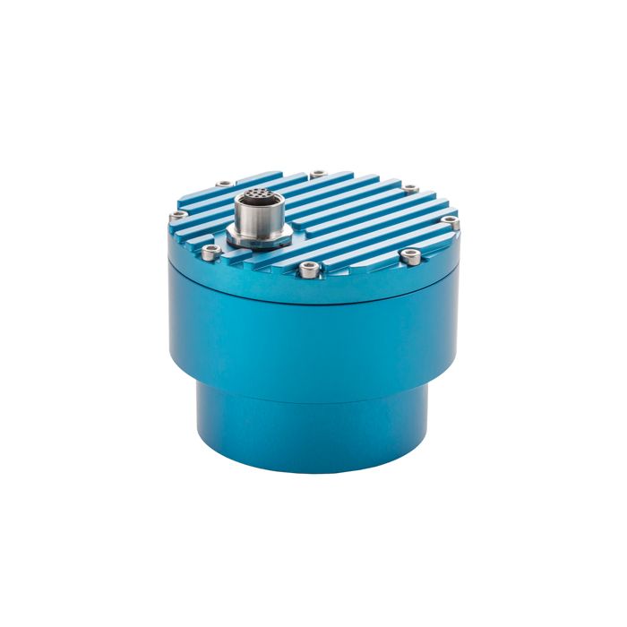
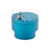
The Geolux Geolux Non-Contact Level Sensors are advanced contactless radar level meters designed for precise distance measurement from the instrument to the water surface for water level and flood monitoring applications.
Features
- Contactless water level measurement
- RS-232, RS-485 Modbus, SDI-12, analog 4-20 mA interfaces in all models
- Robust, small-size IP68 enclosure
Starting At
$1,179.00
Stock
SEE TABLE BELOW
Fondriest Exclusives
- Free ground shipping
- Expedited repair and warranty service
- Lifetime technical support
- More
Overview
The Geolux LX-80 series of instruments are advanced contactless radar level meters designed for precise distance measurement from the instrument to the water surface for water level and flood monitoring applications.
Mechanics
This functionality is achieved by transmitting an electromagnetic wave in 80 GHz frequency range (W band), and measuring the frequency shift of the electromagnetic wave reflected from the water surface. Instruments are characterised by low power consumption, supported by multiple communication interfaces, compatible with third-party dataloggers, and support remote configuration of all instrument settings over any available digital communication interface. Narrow beam width of only 5° allows for simpler installation, and that nearby structures such as bridge railings or pillars do not interfere with the accuracy of the water level measurement.
General Specifications
Radar Type: W-band 77-81 GHz FMCW radar
Beam Angle: 5°
Detection Distance: 8m / 15m / 30m / 50m
Resolution: 0.5mm
Accuracy: +/- 2mm
Sampling Frequency: 1 sample per second
IP Rating: IP68
Electrical & Mechanical
Connector: M12 circular 12 -pin
Input Voltage: 9 to 27 VDC
Power Consumption: 0.36 W; standby 0.15 W; sleep 0.03 W; extended 0.6 W
Max Current: < 470 mA
Temperature Range: -40 °C to +85 °C (without heating or coolers)
Enclosure Dimensions: Φ 65mm x H 78mm
Interface
Serial Interface: 1 x serial RS-485 half-duplex; 1 x serial RS-232 (two wire interface)
Serial Baud Rate: 9600 bps to 115200 bps
Serial Protocols: Modbus, GLX-NMEA
Analog Interface: 4-20 mA
Other Interfaces: SDI-12
Certificates
EN 61326-1:2013
ETSI EN 301 489-1
ETSI EN 301 489-3
EN 62368-1:2014+A11:2007;
EN 60950-22:2017
EN 61010-1:2010
FCC Part 15 class B
ISED RSS211
Questions & Answers
Select Options
Products
0 Item Selected
Image
Part #
Description
Price
Stock
Quantity

LX80-8
Non-contact radar water level sensor, 8m range, 10m cable (mounting bracket sold separately)
$1,179.00
1 Available

LX80-15
Non-contact radar water level sensor, 15m range, 10m cable (mounting bracket sold separately)
$1,611.00
1 Available

LX80-30
Non-contact radar water level sensor, 30m range, 10m cable (mounting bracket sold separately)
$2,514.00
1 Available

LX80-50
Non-contact radar water level sensor, 50m range, 10m cable (mounting bracket sold separately)
$3,300.00
Check Availability
Accessories
0 Item Selected


Notice: At least 1 product is not available to purchase online
Related Products
In The News


