
Geolux Non-Contact Wave & Tide Sensors
The Geolux non-contact wave & tide sensor is a high sampling frequency version of the radar level sensor, which is targeted towards tidal monitoring, oceanographic, coastal and maritime applications.
Features
- Measurement of water level and automatic calculation of wave parameters
- Fast sampling rate of 10 samples per second for accurate wave analysis
- Easy installation up to 15m, 30m or 50m above the water surface
Starting At
$2,711.00
Stock
1
AVAILABLE
Fondriest Exclusives
- Free ground shipping
- Expedited repair and warranty service
- Lifetime technical support
- More
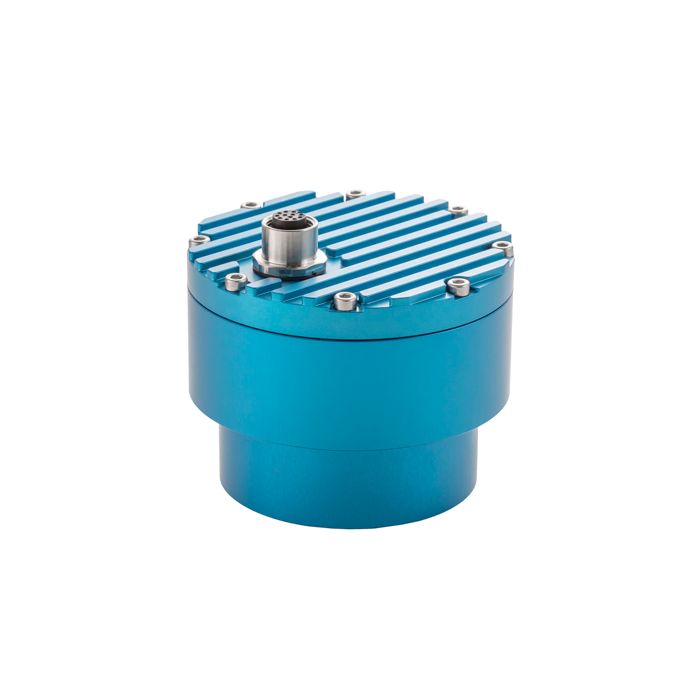
The Geolux non-contact wave sensor is a high sampling frequency version of the radar level sensor, which is targeted towards tidal monitoring, oceanographic, coastal and maritime applications. The level sensor uses radar technology to accurately measure the distance between the radar instrument and the surface of the water. The water level measurements are repeatedly performed 10 times per second. An internal wave analysis module uses these water level measurements for advanced wave analysis.
Wave parameters, such as significant wave height, zero up-crossing period, crest period as well as minimum, maximum, mean and median water level are automatically calculated by the radar unit. The instrument can internally store up to 20 minutes of water level data to be used for calculation of the wave parameters. The low power consumption of the instrument, the integrated wave analysis module, small form factor and a rugged enclosure make this instrument easy to setup and use.
General Specifications
Radar Type: W-band 77-81 GHz FMCW radar
Beam Angle: 5°
Detection Distance: 15m / 30m / 50m
Resolution: 0.5mm
Accuracy: +/- 2 mm
Sampling Frequency: 10 samples per second
IP Rating: IP68
Electrical & Mechanical
Connector: M12 circular 12 -pin
Input Voltage: 9 to 27 VDC
Power Consumption: 0.36 W; standby 0.15 W; sleep 0.03 W; extended 0.6 W
Max Current: < 470 mA
Temperature Range: -40 °C to +85 °C (without heating or coolers)
Enclosure Dimensions: Φ 65mm x H 78mm
Interface
Serial Interface: 1 x serial RS-485 half-duplex; 1 x serial RS-232 (two wire interface)
Serial Baud Rate: 9600 bps to 115200 bps
Serial Protocols: Modbus, GLX-NMEA
Analog Interface: 4-20 mA
Other Interfaces: SDI-12
Certificates
EN 61326-1:2013
ETSI EN 301 489-1
ETSI EN 301 489-3
EN 62368-1:2014+A11:2007;
EN 60950-22:2017
EN 61010-1:2010
FCC Part 15 class B
ISED RSS211
Questions & Answers
Select Options
Products
0 Item Selected
Image
Part #
Description
Price
Stock
Quantity

LX80-O15
Non-contact radar wave & tide sensor, 15m range, 10m cable (mounting bracket sold separately)
$2,711.00
Check Availability

LX80-O30
Non-contact radar wave & tide sensor, 30m range, 10m cable (mounting bracket sold separately)
$3,379.00
1 Available

LX80-O50
Non-contact radar wave & tide sensor, 50m range, 10m cable (mounting bracket sold separately)
$3,771.00
Check Availability
Accessories
0 Item Selected


Notice: At least 1 product is not available to purchase online
Related Products
In The News


