
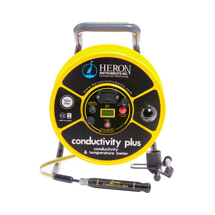
Heron conductivity plus Water Level Meters
The Heron conductivity plus Level and Temperature Meter accurately measures conductivity, water level and temperature in wells, boreholes, stand pipes and open bodies of water.
Features
- High-tensile steel core tape, tested for stretch resistance to ASME standards
- 4-electrode conductivity probe displays values up to 80,000 micro-siemens
- Probe is 7/8" diameter x 5.5" long (2.2cm x 14cm)
Starting At
$1,161.85
Stock
Drop Ships From
Manufacturer
Fondriest Exclusives
- Free ground shipping
- Expedited repair and warranty service
- Lifetime technical support
- More
Overview
The Heron conductivity plus Level and Temperature Meter accurately measures conductivity, water level and temperature in wells, boreholes, stand pipes and open bodies of water. The meter can be used to profile conductivity and temperature to depths of 1000 ft (300m).
Design
The Heron conductivity plus uses a measuring tape with a high tensile steel core, tested for stretch resistance to ASME standards. Two seven strand stainless steel conductors add to the strength of the tape. The tape graduations are in decimal feet with markings at each 1/100th foot or metric with markings at each mm.
A super bright red LED and an 80dB buzzer are also housed in the module. The electronics are based on A/C current, helping prevent probe corrosion and fouling. All electronics are protected from dust and moisture by an epoxy-based conformal coating. The unit is powered by a single 9V battery also housed within the module. The standalone, sturdy steel frame is coated in Polyurethane for durability, and the vinyl-coated carry handle is ergonomically designed for comfort and easier rewinding.
Mechanics
The probe utilizes a four-electrode system comprising of two arrays of a single electrode within a concentric electrode. Water level is sensed when the probe passes from a non-conductive medium (air) to a conductive medium (water). The meter measures the temperature and automatically converts readings to specific conductivity values. Calibration is easy using readily-available 1413us solution. The electronics module houses an LCD screen which displays conductivity values up to 80,000 micro-siemens and a temperature range from 0 C to +50 C.
- Premium Stainless Steel Polyethylene Coated Tape
- 7/8” (22.2mm) Conductivity Probe (IP68) w/ holder
- Electronic Panel with audio and visual signals (Fully Encapsulated to IP65)
- High Contrast LCD Display
- Vinyl, ergonomic holding grip
- 9V Battery
- Backpack Carrying Case w/ adjustable straps, laptop & notepad pouches
- 1 x 1413μ S Conductivity Solution
Questions & Answers
Select Options
Products
0 Item Selected
Image
Part #
Description
Price
Stock
Quantity

1702-100FT
conductivity plus level & temperature meter with imperial increments, 100'
$1,161.85
Drop Ships From
Manufacturer

1702-30M
conductivity plus level & temperature meter with metric increments, 30m
$1,161.85
Drop Ships From
Manufacturer

1702-200FT
conductivity plus level & temperature meter with imperial increments, 200'
$1,289.15
Drop Ships From
Manufacturer

1702-60M
conductivity plus level & temperature meter with metric increments, 60m
$1,289.15
Drop Ships From
Manufacturer

1702-300FT
conductivity plus level & temperature meter with imperial increments, 300'
$1,450.65
Drop Ships From
Manufacturer

1702-100M
conductivity plus level & temperature meter with metric increments, 100m
$1,450.65
Drop Ships From
Manufacturer

1702-500FT
conductivity plus level & temperature meter with imperial increments, 500'
$1,759.40
Drop Ships From
Manufacturer

1702-150M
conductivity plus level & temperature meter with metric increments, 150m
$1,759.40
Drop Ships From
Manufacturer

1702-750FT
conductivity plus level & temperature meter with imperial increments, 750'
$2,228.70
Drop Ships From
Manufacturer

1702-200M
conductivity plus level & temperature meter with metric increments, 200m
$2,228.70
Drop Ships From
Manufacturer

1702-1000FT
conductivity plus level & temperature meter with imperial increments, 1000'
$2,629.60
Drop Ships From
Manufacturer

1702-300M
conductivity plus level & temperature meter with metric increments, 300m
$2,629.60
Drop Ships From
Manufacturer
Accessories
0 Item Selected

Notice: At least 1 product is not available to purchase online
Related Products
In The News


