
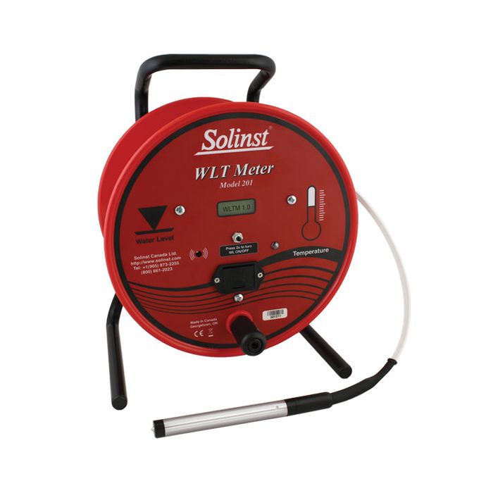
Solinst Model 201 Water Level Temperature Meters
The Model 201 Water Level Temperature (WLT) Meter is ideal for measuring static water levels, as well as profiling temperature in wells, boreholes, tanks and open water.
Features
- Accurately measure temperature from -20ºC to +125ºC
- Corrosion and chemical-resistant PVDF flat tape
- Standard 9V alkaline battery gives 90 hours of use
Starting At
$932.90
Stock
1
AVAILABLE
Fondriest Exclusives
- Free ground shipping
- Expedited repair and warranty service
- Lifetime technical support
- More
Overview
The Model 201 Water Level Temperature (WLT) Meter is ideal for measuring static water levels, as well as profiling temperature in wells, boreholes, tanks and open water. Accurate temperature measurements are clearly displayed on an LCD readout on the faceplate, from -20ºC to +125ºC. Water level and probe depth measurements are read off the Solinst durable PVDF flat tape. Tape lengths are available up to 1000 ft (300m).
High-Quality Materials
The 201 Probe is made of high quality 316 stainless steel. The pressure-proof probe can be submerged to 1000 ft (300m). The zero measurement point on the probe is close to the tip, keeping water displacement at a minimum. The temperature sensor is located at the stainless steel tip of the probe, however, since the probe body acts as a heat sink, best accuracy is obtained when the probe is completely submerged. The tape seal plug design allows the probe to be easily replaced, if required.
The WLT Meter uses extremely durable PVDF flat tape. The tape is non-stretch and has a dog bone design that prevents adherence to wet surfaces. The tape reels smoothly, remains flexible and hangs straight, regardless of temperature. It is also easy to repair and splice. The 3/8" (10mm) wide tape has permanent laser markings every 1/100 ft. or each millimeter, traceable to NIST and EU measurement standards.
Operation
When the meter is turned on, the LCD screen displays the firmware version of the WLT Meter (e.g. “WLTM 1.0”) for about two seconds. The LCD will then display the temperature reading, in or out of water. The LCD menu is simple to operate. Pressing the button two times quickly deactivates the buzzer (the light stays active). To reactivate, press the button two times quickly. To turn the meter off, press and hold the button for two seconds.
When the zero point of the 201 Probe enters water, an electric circuit is completed, activating the buzzer and light. The depth to water is then read off the flat tape. Temperature readings are read off the LCD display. As the probe is lowered to take temperature measurements at discrete depths, the buzzer can be turned off by pressing the button two times quickly. This is ideal when profiling temperature.
Questions & Answers
Select Options
Products
0 Item Selected
Image
Part #
Description
Price
Stock
Quantity

113362
Model 201 WLT water level temperature meter with 5/8" probe & imperial increments, 100'
$932.90
1 Available

113366
Model 201 WLT water level temperature meter with 5/8" probe & metric increments, 30m
$932.90
Check Availability

113364
Model 201 WLT water level temperature meter with 5/8" probe & imperial increments, 200'
$1,103.90
Check Availability

113367
Model 201 WLT water level temperature meter with 5/8" probe & metric increments, 60m
$1,103.90
Check Availability

113365
Model 201 WLT water level temperature meter with 5/8" probe & imperial increments, 300'
$1,274.90
Check Availability

113368
Model 201 WLT water level temperature meter with 5/8" probe & metric increments, 100m
$1,274.90
Check Availability

113414
Model 201 WLT water level temperature meter with 5/8" probe & imperial increments, 500'
$1,886.70
Check Availability

113413
Model 201 WLT water level temperature meter with 5/8" probe & metric increments, 150m
$1,886.70
Check Availability

113416
Model 201 WLT water level temperature meter with 5/8" probe & imperial increments, 750'
$2,314.20
Check Availability

113415
Model 201 WLT water level temperature meter with 5/8" probe & metric increments, 250m
$2,314.20
Check Availability

113418
Model 201 WLT water level temperature meter with 5/8" probe & imperial increments, 1000'
$2,741.70
Check Availability

113417
Model 201 WLT water level temperature meter with 5/8" probe & metric increments, 300m
$2,741.70
Check Availability
Accessories
0 Item Selected


Notice: At least 1 product is not available to purchase online
Related Products
In The News


