
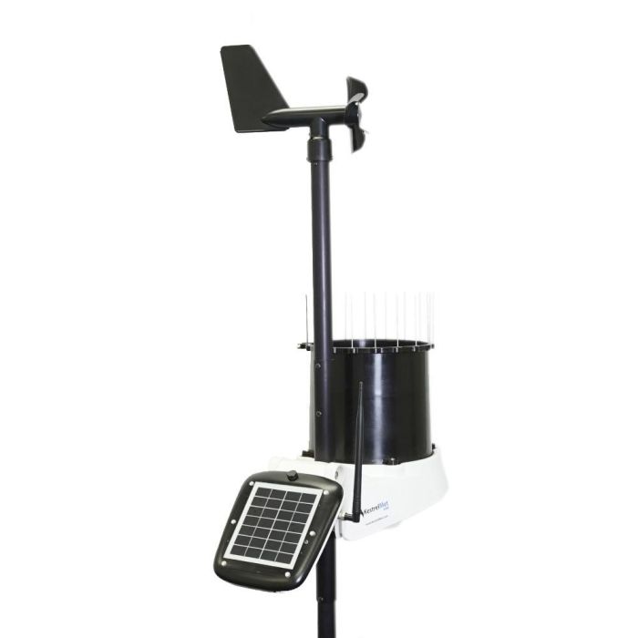
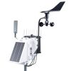
KestrelMet 6000 Wireless Weather Stations
The KestrelMet 6000 is a reliable, cost-effective, all-in-one professional weather station for commercial, industrial, educational, and research applications.
Features
- Measures key weather parameters with wireless Wi-Fi or cellular communication
- Optional leaf wetness, solar irradiance, and soil moisture sensors
- First three months of the cellular data plan included at no additional cost
Starting At
$999.00
Stock
Check
Availability
Fondriest Exclusives
- Expedited repair and warranty service
- Lifetime technical support
- More
Overview
The KestrelMet 6000 is a reliable, cost-effective, all-in-one professional weather station for commercial, industrial, educational, and research applications. It is easily deployable, remote, and arrives pre-assembled for fast set-up and frustration-free installation.
Cellular Stations
Cellular versions of the KestrelMet 6000 come with a low-cost cellular plan through AT&T or Verizon, with the first three months of service provided at no extra charge. Users can access live data through the Ambient Weather Network (AWN) application and portal, making it easy to monitor weather conditions remotely.
*Note: cellular transmission is set at 15-minute intervals.
Mounting Options
Choose between the Mono Mount Kit or the Tripod Mount Kit to best fit research needs. Both options offer quick installation and a secure mounting system. The Mono Mount can be used on a pitched or flat roof and a vertical surface like a gable end. The Tripod can be used on flat terrain, on a flat roof, or the ridge of a pitched roof.
Design
Solar radiation can cause measurement errors and reduce sensor accuracy. Shielding over the air temperature and relative humidity sensors and a 24-hour aspirated fan keeps air moving constantly over the sensors. This significantly improves measurement accuracy compared to passive-shielded weather stations with no aspiration fan.
| Sensors | Accuracy (+/- | Resolution | Range | Notes |
| Wind Speed | larger of 5% or 1 mph between 1 to 57 mph | 0.1 mph 0.1 knot 0.1m/s 0.1 km/hr |
1 to 100 mph 1 to 86.9 knots 1 to 44.7 m/s 1 to 160.9 km/hr |
Wind speed is measured continuously and stored in station memory as a series of 2 second averages. The reported wind speed is the average over the 15 minute logging interval. The highest measured speed during the logging interval is reported as the gust value. |
| Wind Direction | 2° | 1° | 1° - 360° | Wind direction is measured continuously and stored in station memory as a series of 2 second averages. The reported wind direction is the average scalar direction over the 15 minute logging interval. The gust direction is the average scalar direction for the 2 second record corresponding to the gust value. |
| Temperature |
0.45° F |
0.1° F 0.1° C |
-40° to 140° F -40° to 60° C |
Temperature is measured once per minute. The reported temperature is the average value for the 15 minute logging interval. High and low temperatures are based on the 1-minute readings. |
| Relative Humidity | 1.5% between 0 - 80% | 1% | 0 to 100% | Humidity is measured once per minute. The reported humidity is the average value for the 15 minute logging interval. High and low RH are based on the 1-minute readings. |
| Absolute Pressure | 1.5 mbar/hPa 0.044 inHg 1.1 mmHg |
0.1 mbar/hPa 0.01 inHg 0.1 mmHg |
600 to 1100 mbar/hPa 17. 72 to 32.48 inHg 450.0 to 825.1 mmHg |
Pressure is measured once per minute. The reported pressure is the average value for the logging interval. High and low pressures are based on the 1-minute readings. |
| Rain Rate | 5% at 2"/hr | 0.01 in/hr 0.1 mm/hr |
0 to 7.8 in/hr | Rainfall is measured continuously in 0.2 mm increments (tipping bucket calibration volume) |
Questions & Answers
Select Options
Products
0 Item Selected
Image
Part #
Description
Price
Stock
Quantity

0600W
KestrelMet 6000 Wi-Fi weather station
$999.00
Check Availability

0600A
KestrelMet 6000 cellular weather station, AT&T
$1,299.00
Check Availability

0600V
KestrelMet 6000 cellular weather station, Verizon
$1,299.00
Check Availability

0600WL
KestrelMet 6000 Wi-Fi weather station with leaf wetness sensor
$1,148.00
Check Availability

0600AL
KestrelMet 6000 cellular weather station with leaf wetness sensor, AT&T
$1,448.00
Check Availability

0600VL
KestrelMet 6000 cellular weather station with leaf wetness sensor, Verizon
$1,448.00
Check Availability

0600WS
KestrelMet 6000 Wi-Fi weather station with solar irradiance sensor
$1,198.00
Check Availability

0600AS
KestrelMet 6000 cellular weather station with solar irradiance sensor, AT&T
$1,498.00
Check Availability

0600VS
KestrelMet 6000 cellular weather station with solar irradiance sensor, Verizon
$1,498.00
Check Availability

0600WLS
KestrelMet 6000 Wi-Fi weather station with leaf wetness & solar irradiance sensor
$1,347.00
Check Availability

0600ALS
KestrelMet 6000 cellular weather station with leaf wetness & solar irradiance sensor, AT&T
$1,647.00
Check Availability

0600VLS
KestrelMet 6000 cellular weather station with leaf wetness & solar irradiance sensor, Verizon
$1,647.00
Check Availability
Accessories
0 Item Selected


Notice: At least 1 product is not available to purchase online
Related Products
In The News


