
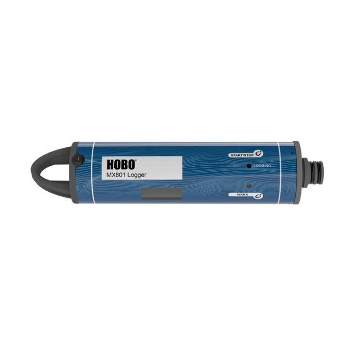
HOBO MX800 Series Water Data Loggers
HOBO MX800 Series wireless data loggers work with interchangeable sensors to provide a highly configurable solution for monitoring water conductivity/salinity, temperature, level, and dissolved oxygen.
Features
- Submersible and direct read options available
- Wireless data offload via Bluetooth 5.0 and HOBOconnect mobile app
- Water detect feature indicates when logger was out of the water
Starting At
$495.00
Stock
SEE TABLE BELOW
Fondriest Exclusives
- Free ground shipping
- Expedited repair and warranty service
- Lifetime technical support
- More
Overview
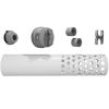
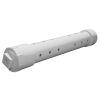
HOBO MX800 Series wireless data loggers work with interchangeable sensors to provide a highly configurable solution for monitoring water conductivity/salinity, temperature, level, and dissolved oxygen. Available in both an easy-to-deploy, fully submersible model (MX801) and a direct read model (MX802) for convenient data offload that doesn’t require having to remove sensors from the water.
Features
- Compatible with interchangeable Conductivity, CTD (conductivity/temperature/depth), and DO sensors (sold separately) - swap out sensors for different applications
- Bluetooth, for easy logger configuration and data offload
- Easy to deploy, fully submersible (MX801)
- Direct read for convenient data offload (MX802)
- Logger diameter is less than 2 inches
- Faster data offload via Bluetooth 5.0
- Water detect feature indicates when logger was out of the water (MX801)
- Barometric pressure sensor included (MX802)
- Connect two sensors to one logger to get measurements like salinity adjusted DO directly, with no need for post processing
- Guided calibration ensures accurate data
- User-replaceable batteries
| MX801 and MX802 | |
| Operating Range | -40° to 50°C (-40° to 122°F), cannot be frozen in ice |
| Radio Power | 1 mW (0 dBm) |
| Transmission Range | Approximately 30.5 m (100 ft) line-of-sight |
| Wireless Data Standard | Bluetooth 5 |
| Maximum Number of Sensors | 2 |
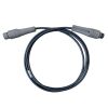
| Maximum Cable Length | 120m (400 ft) |
| Logging Rate | 5 second to 18 hours |
| Logging Modes | Fixed interval (normal or statistics), burst, or multiple intervals with up to 8 user-defined logging intervals and durations, with pause and repeat options |
| Start Modes | Immediate, next interval or date & time |
| Stop Modes | Memory full, never stop (overwrite oldest data), date & time, or after a set logging period |
| Water Detect | Events are logged when logger is submerged or removed from the water (MX801 only) |
| Time Accuracy | ±1 minute per month 0° to 50°C (32° to 122°F) |
| Battery | Four AA, 1.5 V lithium batteries, user replaceable |
| Battery Life | With W-CTD or W-CT sensors: 2 years, typical with 1-minute logging interval or slower |
| With W-DO sensor: 1-year, typical with 5-minute logging interval or slower | |
| Faster logging or statistics sampling intervals, entering burst logging mode, excessive readouts, and remaining connected with the app will impact battery life | |
| Memory | 730,000 measurements, divided between channels (4 Mbyte memory) |
| Data Download Time (Bluetooth 5) | Full memory: Approximately 3.5 minutes |
| 120,000 measurements: 1 minute | |
| May take longer the further the device is from the logger | |
| Dimensions | Logger diameter: 4.14 cm (1.63 inches) |
| Length without sensor: 20 cm (8 inches) | |
| Length with W-CTD sensor: 36 cm (14 inches) | |
| Length with W-CT sensor: 33 cm (13 inches) | |
| Mounting loop: 12.7 x 22.6 mm (0.5 x 0.89 inches) | |
| Weight | Approximately xx g (xx oz) in air; approximately xx g (xx oz) in saltwater |
| Wetted Materials | Logger: PVC housing with polyester film label, PET sensor connector end cap and mounting handle with EPDM and Buna-N O-rings, passivated 316 stainless steel hardware rated for use in saltwater; MX802 also has ePTFE vent |
| Collar: HDPE, titanium screws | |
| Note: logger should be mounted so that no metal parts of the logger are in contact with other metals | |
| Environmental Rating | MX801: IP68; waterproof to 100m (with sensor(s) attached) |
| MX802: IP67, NEMA 6; Weatherproof (with cable or Termination Plug attached); this model is not waterproof | |
| MX802 Barometric Pressure | |
| Measurement & Calibrated Range | 66 to 107 kPa (9.6 to 15.5 psia), -20° to 50°C (-4° to 122°F) |
| Accuracy* | Typical error: ±0.2 kPa (0.029 psi) |
| Maximum error: ±0.5 kPa (0.073 psi) | |
| Resolution | <0.01 kPa (0.0015 psi) |
| Pressure Response Time** | <1 second to 90% at a stable temperature |
| Contribution to Water Level Accuracy*** | Typical error: ±0.075% FS, 0.3 cm (0.01 ft) water |
| Maximum error: ±0.15% FS, 0.6 cm (0.02 ft) water | |
| *Pressure Accuracy: Absolute pressure sensor accuracy includes all sensor drift, temperature, and hysteresis-induced errors. | |
| **Changes in Temperature: Allow 20 minutes in water to achieve full temperature compensation of the pressure sensor. There can be up to 0.5% of additional error due to rapid temperature changes. | |
| ***Water Level Accuracy: With accurate reference water level measurement, known for water density, and a stable temperature environment. System Water Level Accuracy equals the sum of the Barometric Water Level Accuracy plus the selected CTD sensor Water Level Accuracy. | |
- (1) HOBO MX800 data logger
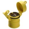
- (1) Coupler
- (1) 3/32" Allen wrench
Questions & Answers
Select Options
Products
0 Item Selected
Image
Part #
Description
Price
Stock
Quantity

MX801
HOBO MX801 submersible water data logger (sensor sold separately)
$495.00
7 Available

MX802
HOBO MX802 direct read water data logger (sensor & cable sold separately)
$495.00
3 Available
Accessories
0 Item Selected


Notice: At least 1 product is not available to purchase online
Related Products
In The News


