- Home
- HOBO TidbiT MX Temp 400 Logger
HOBO TidbiT MX Temp 400 Logger
Features
- Waterproof to 120 meters (400 feet)
- Water detection feature records when the logger is in and out of the water
- Convenient wireless setup and download via Bluetooth Low Energy (BLE)
This item is currently on order from the manufacturer, but it has not yet arrived to our warehouse.
For a current estimate of availability, please call 888-426-2151 or or fill out the form below:
This item drop ships directly from the manufacturer, and the actual lead time is dependent on availability at their warehouse.
For a current estimate of availability, please call 888-426-2151 or or fill out the form below:
Fulfillment times may be longer than usual due to component shortages and other factors outside of our control.
For a current estimate of availability, please call 888-426-2151 or or fill out the form below:
Shipping, Delivery, Order Processing & Product Availability
Fondriest uses the best carriers to make sure orders gets to you on time. Learn more about shipping times, methods, costs, and carriers.
Delivery Time
We keep you informed. Shortly after you place your order, you will receive an Order Acknowledgement email to confirm your order details, including shipping and a delivery estimate. Once your order has been prepared for shipment and ships, you will receive a Shipment Notification email with carrier and tracking information.
Shipping and Delivery Estimates
The 'Ships' timeframe is an estimate of when the item will ship from our warehouse. All items will ship at one time unless you specifically request partial shipment. In which case, the items on your order will ship as they become available. The 'Delivers' timeframe is an estimate of when the item will be delivered to your shipping address after it ships. The estimated delivery time depends on the shipping method you choose during checkout. All estimates are based on business days.
Shipping Options
Fondriest offers several convenient shipping options via UPS.
| Ground Shipping: | Products shipped via ground service are normally delivered within five business days after shipment. |
| 2-Day Shipping: | For an additional charge, Fondriest offers 2-day shipping for most products. Products shipped via two-day service prior to 4:00 p.m. EST are normally delivered by 7:00 p.m. local time two business days after shipment. |
| Overnight Delivery: | For an additional charge, Fondriest offers overnight shipping for most products. Products shipped via overnight service prior to 4:00 p.m. EST are normally delivered by 7:00 p.m. local time one business day after shipment. Earlier overnight delivery options may also be available depending on the destination. |
| Your Account: | For no additional charge, Fondriest can ship on third-party customer accounts via UPS and FedEx. Note that FedEx Ground shipments are picked up the following business day and Express shipments must be made before 1:00 p.m. EST to ensure same-day pick-up. |
Remember that these estimates are for time in transit only, and that they do not apply until the product leaves the Fondriest warehouse. As the delivery of your order is beyond Fondriest's control once your order leaves the Fondriest warehouse, we cannot assume liability for late deliveries, regardless of the delivery method you specify.
Signature Required on Most Deliveries
Most of Fondriest's shipments contain valuable equipment. If you will not be at the shipping address to accept delivery of your product, consider shipping the item to an address where someone you trust will be available to sign for your package, or accept your package if a signature is not required for the delivery. Once your order has prepared for shipment or has shipped, we are unable to change the shipping address. Title and risk of loss to all products will pass to you on delivery. If you are willing to assume the risks of delivering your order without a signature, you may authorize Fondriest to arrange for a delivery that does not require anyone to be at the delivery address.
Undeliverable Packages
Occasionally packages are returned to Fondriest as undeliverable. When the carrier returns an undeliverable package to Fondriest, please contact us to make arrangements for reshipment.
Failed Delivery Attempts
Most of Fondriest carriers make three attempts to deliver a package. After three delivery attempts, the carrier will return the package to Fondriest.
Order Processing
The estimated shipment date on your order is based on product availability, payment processing time, and warehouse processing time and does not include transit time. We do not begin payment processing until Fondriest receives all of the information that is needed and full payment or a full authorization, in the case of credit card or rental orders.
Fondriest will begin payment processing for orders placed on weekends or holidays on the next business day. Business days are Monday through Friday, excluding federal holidays.
Your order for in-stock items that are eligible for same-day shipping must be received before your local time of 2:00 p.m., pending payment processing, for there to be adequate remaining time in the day for your order to be dispatched.
Product Availability
Fondriest makes every effort to ship your product according to the estimated lead times. The estimated lead times are in business days (Monday through Friday, excluding federal holidays).
Although Fondriest makes every effort to ship your order according to the lead time provided, shipping dates may change due to changes in supply. If the lead time changes, Fondriest will contact you via email and provide a revised shipping estimate.
Fondriest makes every effort to supply the products you order, but there may be occasions when Fondriest confirms orders and later learns that it cannot supply the products, either at all or in the quantities ordered. Although rare, these occasions can include when Fondriest learns that the products no longer are being manufactured or they otherwise become unavailable, when Fondriest cannot source components for the configuration you ordered, or when there was a pricing error at the Fondriest Online Store.
In those circumstances, Fondriest will inform you and, if you are interested, Fondriest may suggest alternative products that may meet your needs. If you do not wish to order alternative products, Fondriest will cancel your order for products that cannot be supplied and for any other products that you no longer wish to order as a result, and will refund your purchase price.
We want you to be completely satisfied with your purchase. If you are not, you may initiate a return within 30 calendar days of receiving your item(s). To begin a return, you must request a Return Material Authorization (RMA) by either contacting your account representative or the general customer support address: customercare@fondriest.com. Returns without an RMA will not be accepted.
Items returned for credit must be new, unused, and in the original packaging (including any accessories, manuals, and documentation that shipped with the product). Returned items must be received by Fondriest Environmental within 14 calendar days of the issuance of the RMA. All returned items are subject to inspection and approval prior to the issuance of any credit. If the returned items have been approved, Fondriest will issue a credit based on the original method of payment. Please note that items may be subject to a manufacturer's restocking fee.
Non-Returnable Items: Fondriest does not permit the return of or offer refunds for the following products:
- Configured-to-order or customized products
- Hazardous materials
- Opened calibration reagents
- Opened software
- Software downloads
- Fondriest Gift Cards
Fondriest recommends using a carrier that offers shipment tracking for all returns. Packages should be insured for the full value in case of loss or damage. Fondriest does not assume any liability for loss or damage to the product during shipping.
- Expedited repair and warranty service
- Lifetime technical support
- More
At Fondriest, we are committed to providing high-quality products at affordable prices with the industry's best support. Additionally, we offer:
-
Discounts
High volume purchases lead to favorable pricing, which is passed on to the customer by way of discount off MSRP.
-
Assembly, Test and Calibration
Sensors and instruments are assembled, tested and calibrated prior to shipment. A calibration report is included.
-
Lifetime Technical Support
A knowledgeable staff of applications engineers provides ongoing support for the life of the product.
-
Product Training
Applications engineers are available for webinars or personalized, on-site startup and training. Extensive measurement technology, product troubleshooting and instrument repair workshops are offered at the Field Station.
-
Extended Warranties
Warranties extended beyond factory standards are offered on many items to ensure a lasting useful life.
-
Repair
A factory-authorized service center provides fast turnaround product repair and annual maintenance.
-
Rental
Rental equipment is available to minimize downtime and cover equipment needs when projects expand.
-
Communications
Call, email or chat online with applications engineers. Email correspondence is responsive and a toll-free number is available for added convenience.
-
Quick Ship
Many orders ship on the same day and expedited shipping is available. If a product cannot be shipped immediately, customers are notified by phone or email.
-
Discounts
Overview
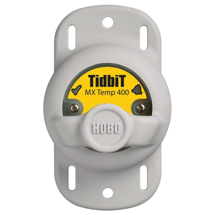
The Onset HOBO MX2203 TidbiT waterproof temperature logger leverages the power of Bluetooth Low Energy (BLE) to deliver high-accuracy temperature measurements straight to a mobile device or Windows computer with Onset's free HOBOconnect app. Designed for durability, this rugged, waterproof logger is ideal for long-term deployments in streams, lakes, and oceans (up to 400-foot depths). The Onset HOBO MX2203 also provides the additional feature to detect and record the presence of water, which is ideal for monitoring intermittent water applications.
Benefits
- Convenient wireless setup and download via Bluetooth Low Energy (BLE)
- Large memory stores 96,000 measurements
- Waterproof to 120 meters (400 feet)
- Water detection feature records when the logger is in and out of the water
- User-replaceable battery
- Waterproof boot protects the logger during deployment
- LED alarm notifies when temperature exceeds the set threshold
- Battery life extension feature
- Works with Onset’s free HOBOconnect app
- ±0.2°C (±0.36°F) accuracy
- Data Logger
- Protective Boot
Select Options


have been added to your cart
There are items in your cart.
Cart Subtotal: $xxx.xx
We can't add this item to your shopping cart right now. Please reload the page.
Please first select the items and quantities to add to your Cart.
In The News

Flow Photo Explorer: Studying Flows in the Penobscot River Basin
The flow dynamics of rivers and streams play an essential role in the chemical and physical functions of aquatic ecosystems. In Maine, varying flows in the Penobscot River Basin have impacted the health of the ecosystem, water resource use, and habitat suitability for native species—topics of particular concern to the Penobscot Indian Nation , who have been protecting and managing the waterway for millennia. Parts of the Penobscot basin have been monitored by the USGS stream gage network, which covers larger streams and rivers but excludes many of the small streams found on tribal lands.
Monitoring Meadowbrook Creek: Real-Time Data Collection in an Urban Creek
Meadowbrook Creek in Syracuse, New York, has been monitored by Syracuse University (SU) faculty and students for over a decade. Originally established by Dr. Laura Lautz in 2012, the early years of the program focused on collecting grab water samples for laboratory analysis and evaluating the impact of urban land use, human activities, and natural processes on water resources. Tao Wen , an Assistant Professor in SU’s Department of Earth and Environmental Sciences, took over the program in 2020 and upgraded the existing systems to include 4G modems that allowed for real-time data viewing. Monitoring Efforts on Meadowbrook Creek Three continuous monitoring sites along the urban creek measure water depth, water temperature, and conductivity every fifteen minutes.
Source Water Monitoring: How Fayette County Finds the Highest Drinking Water Quality
Safe drinking water is vital for public health infrastructure, and providing cost-effective water treatment is a top goal of drinking water utilities. To reduce these costs, counties like Fayette, Georgia, rely on source water monitoring to evaluate water quality before it reaches the treatment plant. Fayette County Water System serves about 90,000 residents and pulls water from multiple reservoirs in the area. This variety of sources offers unique benefits for the county. They have built a system that minimizes cost and maximizes choice–two water treatment plants, multiple water pumps, and multiple reservoirs. Two of the reservoirs have intake structures that allow water treatment staff to choose which level of the water column has the best quality, within 2-foot increments.


