
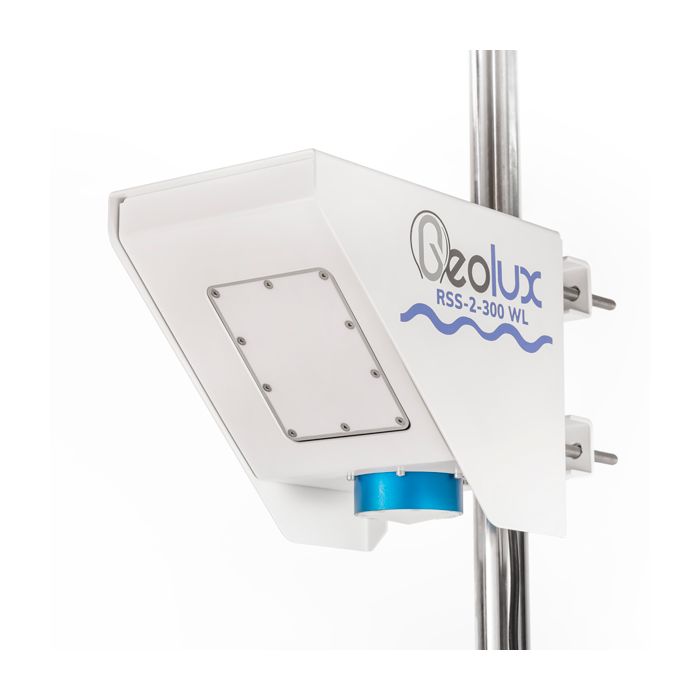
Geolux Non-Contact Flow Sensors
The Geolux Non-Contact Flow Sensor has an integrated radar surface velocity and level sensor for contactless velocity, level, and volumetric flow measurements.
Features
- Contactless water level and surface velocity measurement
- Integrated discharge (flow) calculation
- RS-232, RS-485 Modbus, SDI-12, analog 4-20 mA interfaces in all models
Starting At
$5,029.00
Stock
1
AVAILABLE
Fondriest Exclusives
- Free ground shipping
- Expedited repair and warranty service
- Lifetime technical support
- More
Oerview
The Geolux Non-Contact Flow Sensor has an integrated radar surface velocity and level sensor for contactless velocity, level, and discharge (flow) measurements.
Mechanics
Contactless radar technology enables quick and simple sensor installation above the water surface with minimum maintenance. Calculation of the total flow discharge is internally implemented within the instrument by combining surface velocity measurement, water level measurement, and a configured cross-section of the river or channel. Defining the measurement parameters such as profile cross-section, material of the edges, location of the sensor above the water, and all other instrument settings can be easily set with the Geolux configuration application using any available communication interface.
General Specifications
Detection Distance: 15m / 30m / 50m
Speed Range: 0.02m/s to 15m/s
Speed Resolution: 0.001m/s
Speed Accuracy: 1%
Level Resolution: 0.5mm
Level Accuracy: +/-2mm
IP Rating: IP68
Electrical & Mechanical
Input Voltage: 9 to 27 VDC
Power Consumption: 1,3 W operational; 0,235 W standby
Maximal Current: < 750 mA
Temperature Range: -40 °C to +85 °C (without heating or coolers)
Enclosure Dimensions: 150mm x 200mm x 250mm
Weight: 3.08kg
Interface
Serial Interface: 1 x serial RS-485 half-duplex; 1 x serial RS-232 (two wire interface)
Baud Rate: 9600 bps to 115200 bps
Serial Protocols: Modbus, GLX-NMEA
Other Protocols: SDI-12
Analog Output: 4-20 mA, programmable velocity, level or flow
Certificates
EN 61326-1:2013
ETSI EN 301 489-1
ETSI EN 301 489-3
EN 301 489-3 V2.1.1:2019
EN 301 489-1 V2.2.3:2019
EN 300 440 V2.2.1:2018
EN 62368-1:2014+A11:2007;
EN 60950-22:2017
EN 61010-1:2010
FCC Part 15 class B
ISED RSS211
Questions & Answers
Select Options
Products
0 Item Selected
Image
Part #
Description
Price
Stock
Quantity

RSS-2-300WL
Non-contact radar water level, surface velocity & flow sensor, 15m range, 10m cable
$5,029.00
1 Available

RSS-2-300WL-30
Non-contact radar water level, surface velocity & flow sensor, 30m range, 10m cable
$5,971.00
Check Availability

RSS-2-300WL-50
Non-contact radar water level, surface velocity & flow sensor, 50m range, 10m cable
$6,286.00
Check Availability
Accessories
0 Item Selected


Notice: At least 1 product is not available to purchase online
Related Products
In The News


