
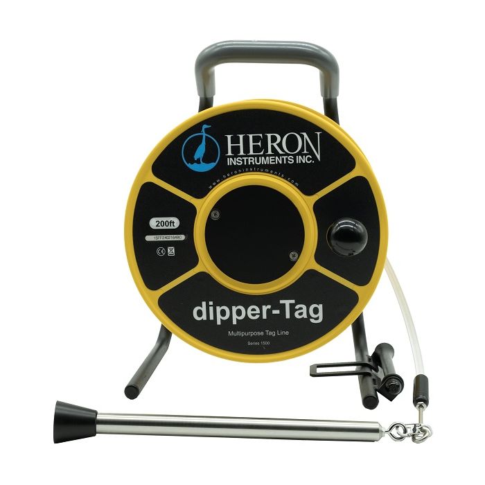
Heron dipper-Tag Tag Lines
The Heron dipper-Tag Tag Lines are a multi-purpose tag line designed for use when installing or monitoring wells.
Features
- Included 1” (25.4mm) stainless steel (Grade 316) plopper
- Kevlar reinforced polyethylene tape with metric (mm) or engineering scale (1/100') markings
- Includes carry bag to protect the tag line from the elements
Starting At
$499.70
Stock
Drop Ships From
Manufacturer
Fondriest Exclusives
- Free ground shipping
- Expedited repair and warranty service
- Lifetime technical support
- More
Overview
The Heron dipper-Tag Tag Lines are a multi-purpose tag line designed for use when installing or monitoring wells. The 316 grade s/s weighted plopper that comes with the dipper-Tag can be used for measuring to the bottom of a well, or the depth to the top of a bentonite layer or backfill sand. The plopper can also be used to measure to the top of the water level acoustically. The spring release clip allows the user to exchange the plopper to other instruments, such as a water level logger or bailer.
- Polyethylene Tape
- 3/4″ Stainless Steel (Grade 316) weight with removable Plopper
- Stainless Steel Spring Clip – to attach included weight / plopper or other attachments (Bailers/Data Loggers/dipper-See H2GO/etc.)
- Vinyl ergonomic handle
- (3x) 1.5″ x 12″ biodegradable bailers
- Backpack Carrying Case w/ adjustable straps, laptop & notepad pouches
Questions & Answers
Select Options
Products
0 Item Selected
Image
Part #
Description
Price
Stock
Quantity

1500-100FT
dipper-Tag tag line with 1" plopper & imperial increments, 100'
$499.70
Drop Ships From
Manufacturer

1500-30M
dipper-Tag tag line with 1" plopper & metric increments, 30m
$499.70
Drop Ships From
Manufacturer

1500-200FT
dipper-Tag tag line with 1" plopper & imperial increments, 200'
$613.70
Drop Ships From
Manufacturer

1500-60M
dipper-Tag tag line with 1" plopper & metric increments, 60m
$613.70
Drop Ships From
Manufacturer

1500-300FT
dipper-Tag tag line with 1" plopper & imperial increments, 300'
$725.80
Drop Ships From
Manufacturer

1500-100M
dipper-Tag tag line with 1" plopper & metric increments, 100m
$725.80
Drop Ships From
Manufacturer

1500-500FT
dipper-Tag tag line with 1" plopper & imperial increments, 500'
$1,007.00
Drop Ships From
Manufacturer

1500-150M
dipper-Tag tag line with 1" plopper & metric increments, 150m
$1,007.00
Drop Ships From
Manufacturer

1500-750FT
dipper-Tag tag line with 1" plopper & imperial increments, 750'
$1,363.25
Drop Ships From
Manufacturer

1500-200M
dipper-Tag tag line with 1" plopper & metric increments, 200m
$1,363.25
Drop Ships From
Manufacturer

1500-1000FT
dipper-Tag tag line with 1" plopper & imperial increments, 1000'
$1,816.40
Drop Ships From
Manufacturer

1500-300M
dipper-Tag tag line with 1" plopper & metric increments, 300m
$1,816.40
Drop Ships From
Manufacturer
Notice: At least 1 product is not available to purchase online
Related Products
In The News


