
Solinst Model 103 Wireline Tag Lines
The Solinst Model 103 Wireline Tag Line is a multi-purpose solution for pump deployments, measuring depth to the bottom of a well, or support line for down-well samplers and data loggers.
Features
- Markings are laser etched every 1/4 foot or every 5 centimeters of the cable
- Standard tag weight measures 1.5 lbs and is 3/4" x 12" (included)
- Includes tape guide to protect the wireline from damage on rough edges
Starting At
$333.45
Stock
Check
Availability
Fondriest Exclusives
- Free ground shipping
- Expedited repair and warranty service
- Lifetime technical support
- More
Overview
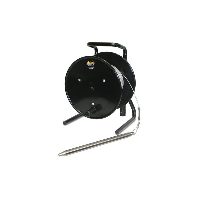
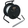
The Solinst Model 103 Wireline Tag Line uses a weight attached to a laser marked cable, and is principally designed for use during the installation of monitoring wells. The Tag Line also provides a simple method to measure the depth to the bottom of a well. It is also ideal as a multipurpose marked support cable. Markings are clearly and accurately laser etched every 1/4 foot or every 5 centimeters of the cable. The laser markings allow the cable to run smoothly over the Tape Guide.
Design
The Model 103 Wireline Tag Line uses durable polyethylene coated 1/16"" (1.6 mm) stranded stainless steel wireline with a minimum break strength of 270 lbs (122 kg). It comes in standard lengths of 100 ft. to 1000 ft. (30 m to 300 m). The cable is mounted on a sturdy free-standing reel with a carrying handle, weight holder and brake. The standard stainless steel tag weight is 1.5 lbs (0.68 kg) and measures 3/4" x 1 ft. (19 mm x 30 cm). A narrow tag weight, 1/2" x 1 ft. (13 mm x 30 cm), weighing 0.65 lbs (0.30 kg), is also an option.
Applications
Tag weights have tapered ends to minimize hang-ups during deployment and return to surface, and can be clipped on and off the cable. This allows the use of the reel-mounted marked cable for other uses, such as bailer, or pump, and packer deployment.
- (1) Solinst Model 103 Tag line mounted on reel
- (1) 3/4" x 1' tag weight
- (1) Tape guide
Questions & Answers
Select Options
Products
0 Item Selected
Image
Part #
Description
Price
Stock
Quantity

106132
Model 103 wireline tag line with 3/4" x 12" weight & imperial increments, 100'
$333.45
Check Availability

106299
Model 103 wireline tag line with 3/4" x 12" weight & metric increments, 30m
$333.45
Check Availability

106300
Model 103 wireline tag line with 3/4" x 12" weight & imperial increments, 200'
$428.45
Check Availability

106306
Model 103 wireline tag line with 3/4" x 12" weight & metric increments, 60m
$428.45
Check Availability

106142
Model 103 wireline tag line with 3/4" x 12" weight & imperial increments, 300'
$523.45
Check Availability

106172
Model 103 wireline tag line with 3/4" x 12" weight & metric increments, 100m
$523.45
Check Availability

106302
Model 103 wireline tag line with 3/4" x 12" weight & imperial increments, 500'
$713.45
Check Availability

106308
Model 103 wireline tag line with 3/4" x 12" weight & metric increments, 150m
$713.45
Check Availability

106304
Model 103 wireline tag line with 3/4" x 12" weight & imperial increments, 750'
$950.95
Check Availability

106310
Model 103 wireline tag line with 3/4" x 12" weight & metric increments, 250m
$950.95
Check Availability

106305
Model 103 wireline tag line with 3/4" x 12" weight & imperial increments, 1000'
$1,188.45
Check Availability

106311
Model 103 wireline tag line with 3/4" x 12" weight & metric increments, 300m
$1,188.45
Check Availability
Accessories
0 Item Selected


Notice: At least 1 product is not available to purchase online
Related Products
In The News


