
Solinst Model 103 Flat Tape Tag Lines
The Solinst Model 103 Flat Tape Tag Line is a multi-purpose solution for pump deployments, measuring depth to the bottom of a well, or support line for down-well samplers and data loggers.
Features
- Markings are laser etched every 1/100 ft or each mm
- Standard tag weight measures 1.5 lbs and is 3/4" x 12" (included)
- Includes tape guide to protect the tape from damage on rough edges
Starting At
$399.95
Stock
Check
Availability
Fondriest Exclusives
- Free ground shipping
- Expedited repair and warranty service
- Lifetime technical support
- More
Overview
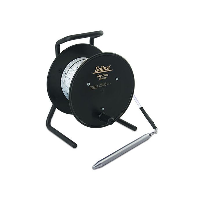
The Solinst Tag Line uses a weight attached to a laser-marked flat tape and is principally designed for use during the installation of monitoring wells. The Tag Line also provides a simple method to measure the depth to the bottom of a well. It is also ideal as a multipurpose marked support cable.
Design
The Model 103 Flat Tape Tag Line uses a 3/8" (10 mm) PVDF flat tape. The tape has a break strength of greater than 220 lbs (100 kg). It has a thick dog bone design that prevents adherence to wet surfaces and allows it to hang straight. The well tape comes with laser markings every 1/100 ft. or each millimeter. Lengths are 100 ft to 1000 ft. (30 m to 300 m).
The standard stainless steel tag weight is 1.5 lbs (0.68 kg) and measures 3/4" x 1 ft. (19 mm x 30 cm). A narrow tag weight, 1/2" x 1 ft. (13 mm x 30 cm), weighing 0.65 lbs (0.30 kg), is also an option. Tag weights have tapered ends to minimize hang-ups during deployment and return to the surface and can be clipped on and off the tape. This allows the use of the reel-mounted marked well tape for other uses, such as bailer or pump, and packer deployment.
- (1) Solinst Model 103 Tag line mounted on reel
- (1) 3/4" x 1' tag weight
- (1) Tape guide
Questions & Answers
Select Options
Products
0 Item Selected
Image
Part #
Description
Price
Stock
Quantity

110568
Model 103 flat tape tag line with 3/4" x 12" weight & imperial increments, 100'
$399.95
Check Availability

110574
Model 103 flat tape tag line with 3/4" x 12" weight & metric increments, 30m
$399.95
Check Availability

110569
Model 103 flat tape tag line with 3/4" x 12" weight & imperial increments, 200'
$570.95
Check Availability

110575
Model 103 flat tape tag line with 3/4" x 12" weight & metric increments, 60m
$570.95
Check Availability

110570
Model 103 flat tape tag line with 3/4" x 12" weight & imperial increments, 300'
$741.95
Check Availability

110576
Model 103 flat tape tag line with 3/4" x 12" weight & metric increments, 100m
$741.95
Check Availability

110571
Model 103 flat tape tag line with 3/4" x 12" weight & imperial increments, 500'
$1,088.70
Check Availability

110577
Model 103 flat tape tag line with 3/4" x 12" weight & metric increments, 150m
$1,088.70
Check Availability

110572
Model 103 flat tape tag line with 3/4" x 12" weight & imperial increments, 750'
$1,516.20
Check Availability

110578
Model 103 flat tape tag line with 3/4" x 12" weight & metric increments, 250m
$1,516.20
Check Availability

110573
Model 103 flat tape tag line with 3/4" x 12" weight & imperial increments, 1000'
$1,943.70
Check Availability

110579
Model 103 flat tape tag line with 3/4" x 12" weight & metric increments, 300m
$1,943.70
Check Availability
Accessories
0 Item Selected


Notice: At least 1 product is not available to purchase online
Related Products
In The News


