
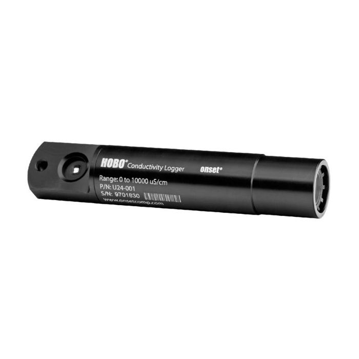
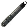
HOBO Fresh Water Conductivity Logger
The HOBO U24 measures and records both conductivity and temperature in streams, lakes, and other freshwater sources.
Features
- Non-contact sensor provides long life and less measurement drift
- Provides easy access to sensor for cleaning and shedding air bubbles
- Requires HOBOware Pro Software and optic base station or waterproof shuttle
Your Price
$1,015.00
Stock
Check
Availability
Fondriest Exclusives
- Free ground shipping
- Expedited repair and warranty service
- Lifetime technical support
- More
Overview
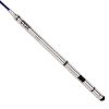
The HOBO U24 high-accuracy conductivity data logger is a cost-effective solution for collecting water quality data. The HOBO U24 measures and records both conductivity and temperature in streams, lakes, and other freshwater sources. The HOBO U24 logger is recommended for monitoring aquifers for saltwater intrusion and road and agricultural runoff. This product’s open access to its sensor simplifies cleaning and maintenance. The U24’s non-contact sensor minimizes measurement errors related to drift and features software-based drift compensation.
Low-Maintenance
The HOBO U24 Conductivity data logger features a non-contact sensor with a Titanium Pentoxide coating. This coating prevents the sensor from coming in contact with the water, which in turn prevents tarnishing or corrosion associated with traditional electrode sensors. This sensor coating is also inert, enabling fouling to be easily wiped off the sensor.
| Measurements | Actual Conductivity, Temperature, Specific Conductance at 25°C (calculated) |
| Conductivity Calibrated Measurement Ranges | Low Range: 0 to 1,000 µS/cm Full Range: 0 to 10,000 µS/cm |
| Conductivity Calibrated Range - Temperature Range | 5° to 35°C (41° to 95°F) |
| Conductivity Extended Ranges | Low Range: 0 to 2,500 µS/cm Full Range: 0 to 15,000 µS/cm |
| Temperature Measurement Range | -2° to 36°C (28° to 97°F) |
| Specific Conductance Accuracy (in Calibrated Range) | Low Range: 3% of reading, or 5 µS/cm, and Full Range: 3% of reading, or 20 µS/cm, whichever is greater, using Conductivity Data Assistant and calibration measurements |
| Conductivity Resolution | 1 µS/cm |
| Temperature Accuracy | 0.1°C (0.2°F) at 25°C (77°F) |
| Temperature Resolution | 0.01°C (0.02°F) |
| Conductivity Drift | Less than 3% sensor drift per year, exclusive of drift from fouling |
| Response Time | 1 second to 90% of change (in water) |
| Operating Range | -2° to 36°C (28° to 97°F) - non-freezing |
| Memory | 18,500 temperature and conductivity measurements when using one conductivity range; 11,500 sets of measurements when using both conductivity ranges (64 KB total memory) |
| Sample Rate | 1 second to 18 hrs, fixed or multiple-rate sampling with up to 8 user-defined sampling intervals |
| Clock Accuracy | ±1 minute per month |
| Battery | 3.6 Volt lithium battery |
| Battery Life | 3 years (at 1 minute logging) |
| Maximum Depth | 70 m (225 ft) |
| Weight | 193 g (6.82 oz), buoyancy in freshwater: -59.8 g (-2.11 oz) |
| Size | 3.18 cm diameter x 16.5 cm, with 6.3 mm mounting hole (1.25 in. diameter x 6.5 in., 0.25 in. hole) |
| Wetted Housing Materials | Delrin®, epoxy, stainless steel retaining ring, polypropylene, Buna rubber O-ring, titanium pentoxide (inert coating over sensor) |
| Environmental Rating | IP68 |
- HOBO U24-001 Conductivity Data Logger
- Communications window protective cap
Questions & Answers
Select Options
Products
0 Item Selected
Image
Part #
Description
Price
Stock
Quantity

U24-001
HOBO fresh water conductivity & temperature logger, 0 to 10,000 uS/cm range
$1,015.00
Check Availability
Accessories
0 Item Selected


Notice: At least 1 product is not available to purchase online
Related Products
In The News


